Live Updates: Tornado Warning Issued For Cherokee and Wagoner, Adair, Cherokee, Muskogee, & Sequoyah County
Oklahoma Weather Forecast: Bookmark this page and refresh it often for the latest forecast and daily updates.Monday, November 4th 2024, 2:58 pm
TULSA, Okla. -
Strong are moving across the state on Monday afternoon with Tornadoes, heavy rain, and strong winds, and some hail are anticipated with most of the storm systems.
WATCH LIVE: SEVERE WEATHER COVERAGE
A confirmed tornado moved quickly northeast over Lake Tenkiller and to Cookson around 3 pm. Chief Meteorologist Travis Meyer said this will track up toward Keys and eventually Tahlequah.

The Talala area, experienced tornado-like weather around 1 p.m. News On 6 has crews working to gather information from that event.
Watches And Warnings:
Monday's storms are split into two powerful sections with one storm covering the north and one to the south.
A Tornado Warning has been issued for Cherokee and Wagoner County until 3:15 p.m.
To the southeast Tornado Warnings have been issued for Adair, Cherokee, Muskogee, and Sequoyah County until 3:30 pm.
To the North, a Severe Thunderstorm Warning has been issued for Ottawa County until 3:30 pm.
A Tornado Watch has been issued for Adair, Cherokee, Craig, Creek, Delaware, Haskell, Hughes, Latimer, Le Flore, Lincoln, McIntosh, Mayes, Muskogee, Nowata, Okfuskee, Okmulgee, Osage, Ottawa, Pawnee, Pittsburg, Pushmataha and Rogers, Sequoyah, Tulsa, Wagoner, and Washington County until 6:00 pm.

Oklahoma Rainfall
Several rounds of heavy rainfall have brought multi-inch totals across the area, and additional pockets of heavy rain will continue until the main system exits.
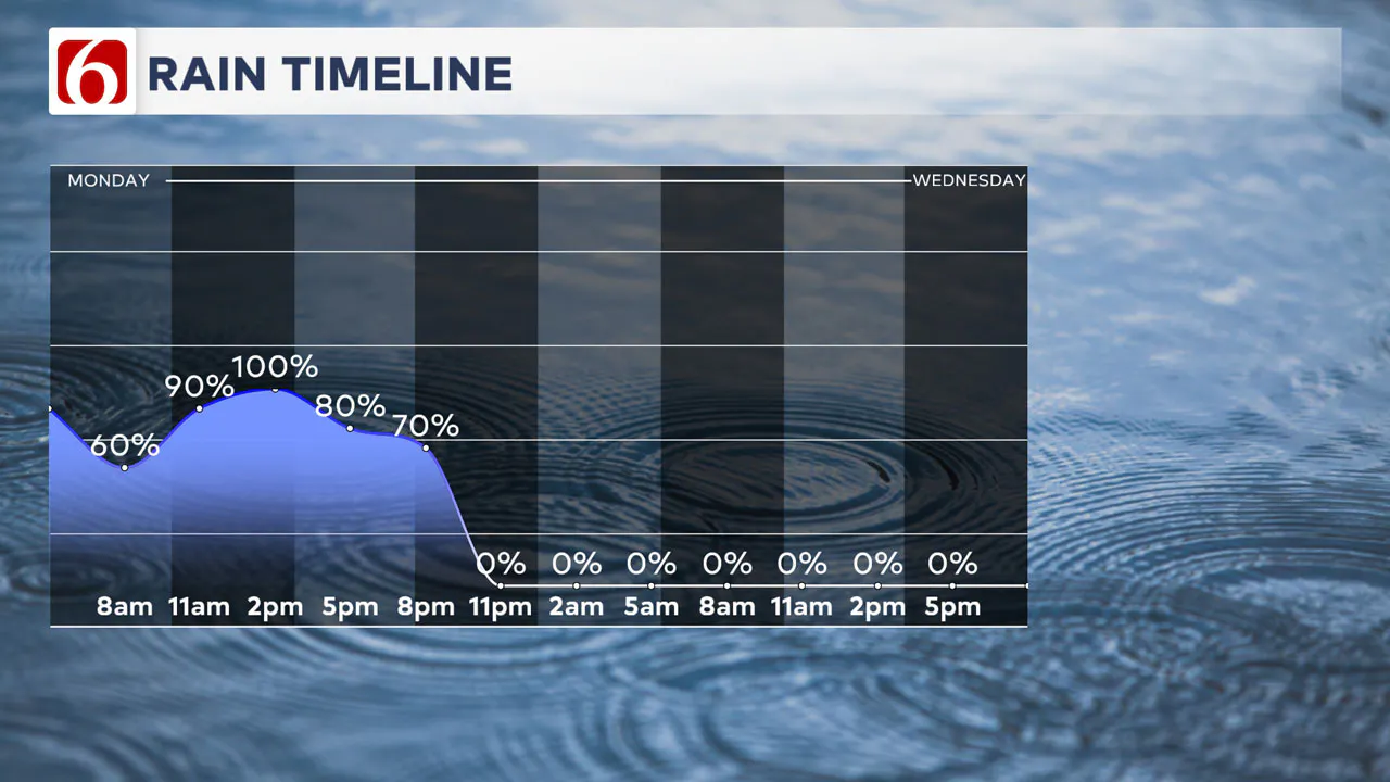
Local flood warnings remain in some locations this morning while a large part of the area also remains under a Flood Watch until this evening. Scattered storms remain across eastern Oklahoma this morning, producing heavy rainfall. A few cells may produce gusty winds and some hail.
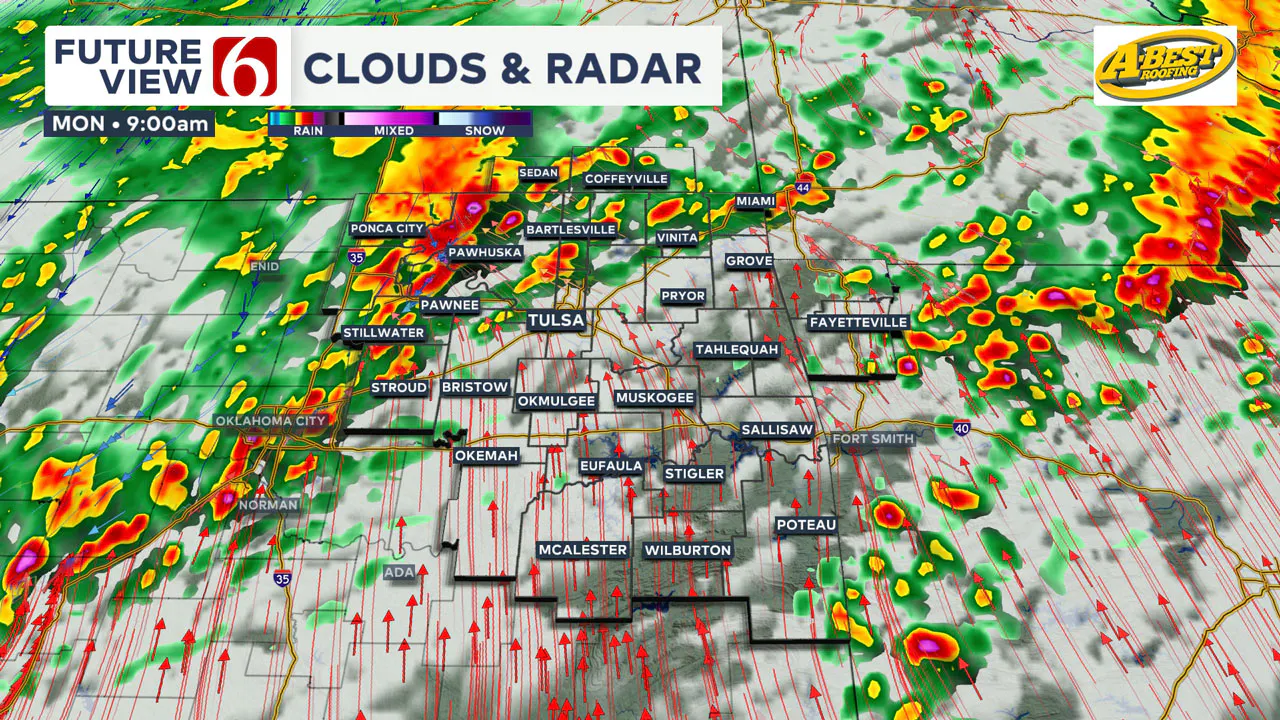
A warm front is positioned across southern OK early this morning and will begin surging northwestward as the main upper-level trough draws closer and air pressure begins to fall. A surface area of low pressure should develop across the western areas of north Texas early this morning and move into central OK around noon to 1 p.m.
Later this morning into the afternoon, the main upper-level system will approach the region, bringing a dry line and a Pacific cold front into the area and additional severe storm chances. All modes of severe weather will be possible, including tornadoes.
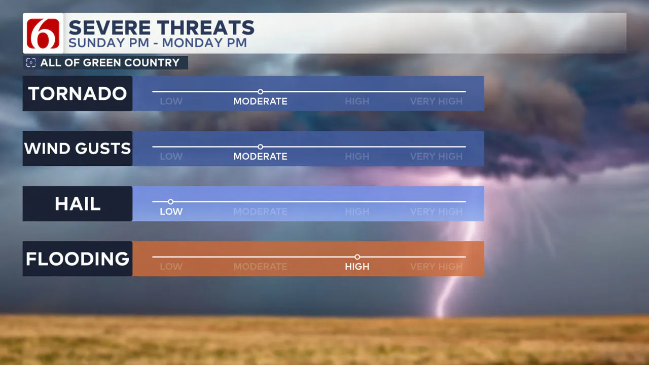
Additional tornado watches will likely be issued later today for locations along and east of the I-44 corridor across the eastern third of the state into Arkansas and surrounding areas.
Highs today will reach the lower 70s with storm chances, including severe threats by at least midday to afternoon moving from the metro eastward into Arkansas later tonight. South winds at 15 to 25 mph will be likely with mostly cloudy conditions.
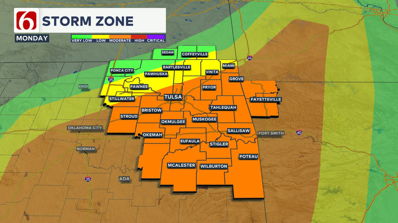
This low will move northeast this afternoon. A dry line will be associated with the surface low. Along and ahead of the dry line and near and south of the warm front will be the highest chance of tornadoes later today and early evening. Damaging wind gusts will also be possible along with some hail.
While scattered storms will remain this morning across the eastern third of the state, additional strong to severe storm chances will return early afternoon near I-35, moving near the Tulsa metro around 3 p.m. and along and east of Highway 69 around 6 p.m. to 8 p.m.
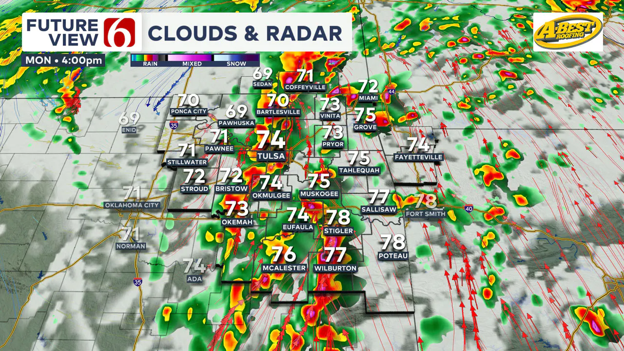
Most of the storms will be exiting the state around 8 p.m. to 9 p.m. Please understand that thunderstorm timing is subject to change.
The front should clear the area later this evening with cooler and drier air following the frontal passage. The strong upper-level jet, featuring mid-level winds from 90 to 100 knots will not clear the area until early Tuesday morning but we anticipate dry air will wrap into the system quickly ending precipitation as it ejects away from the state.
The exception may be a few spotty showers early Tuesday morning across far southeastern OK. Seasonal and pleasant conditions will be likely for Election Day and Wednesday, before another strong upper-level system begins to influence our weather Thursday through part of the weekend with additional thunderstorm chances, including severe weather threats.
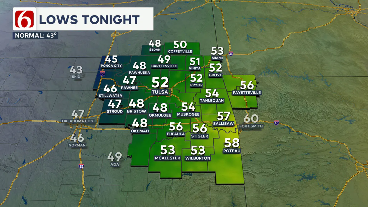
Election Day features decreasing clouds with morning lows in the upper 40s and lower 50s with highs in the lower to mid-60s. Light north winds are likely for most of the day into early Wednesday morning with morning lows in the lower to mid-40s.
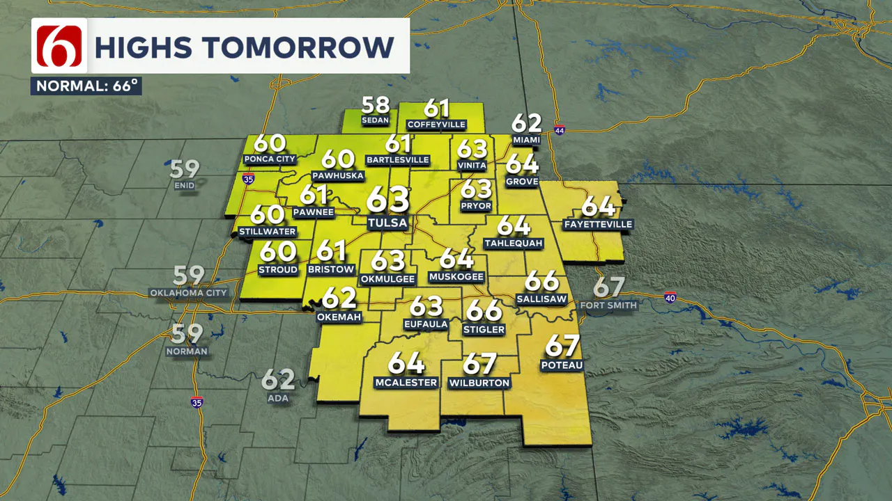
South winds return Wednesday afternoon at 10 to 15 mph with partly cloudy sky and highs in the mid to upper 60s.
Some inconsistencies in the data will keep storm chances spread from Thursday through at least Saturday until some higher confidence arrives in any one specific scenario for higher chances of storms. Based on the upper air pattern, severe weather threats will be mentioned from Thursday evening through part of the weekend.
Emergency Info: Outages Across Oklahoma:
Northeast Oklahoma has various power companies and electric cooperatives, many of which have overlapping areas of coverage. Below is a link to various outage maps.
Indian Electric Cooperative (IEC) Outage Map
Oklahoma Association of Electric Cooperatives Outage Map — (Note Several Smaller Co-ops Included)
The Alan Crone morning weather podcast link from Spotify:
https://open.spotify.com/show/0dCHRWMFjs4fEPKLqTLjvy
The Alan Crone morning weather podcast link from Apple:
Follow the News On 6 Meteorologists on Facebook!

More Like This
November 4th, 2024
November 4th, 2024
November 4th, 2024
November 4th, 2024
Top Headlines
November 4th, 2024
November 4th, 2024
November 4th, 2024


