Green Country Braces For Arctic Blast, Snow & Single-Digit Temps
<p>Arctic air is plunging into eastern Oklahoma for our Saturday, and by the end of the day we could see our first snow of the season. </p>Saturday, December 17th 2016, 9:50 am
Arctic air is plunging into eastern Oklahoma for our Saturday, and by the end of the day we could see our first snow of the season!
Temperatures will continue to free-fall throughout the day, with increasing north winds leading to bitterly cold wind chill values. Temperatures will likely begin dipping below freezing by late morning or lunchtime in the Tulsa metro, so any areas of drizzle could become freezing drizzle by lunchtime into early afternoon and could lead to slick spots on bridges and overpasses. Please be aware!
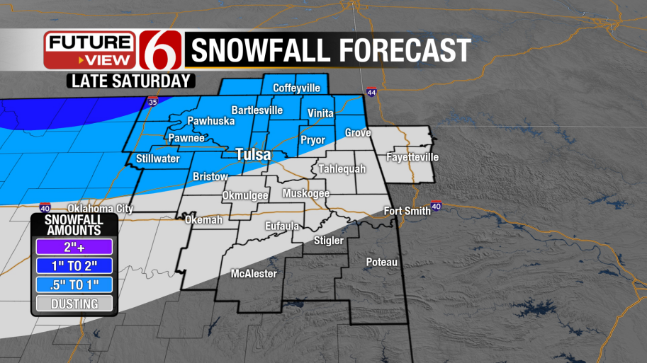
Our temperatures will continue to tumble into the 20s by mid to late afternoon with wind chill values already dipping into the teens and single digits across northeast Oklahoma! Areas of light snow are still expected to move into northeast Oklahoma, beginning after 4 p.m. and lasting through about 10 p.m. before tapering off across southeast Oklahoma. Snow appears most likely in the Tulsa metro from about 6 p.m. to 9 p.m. tonight.
Snowfall accumulations will be low, with most locations likely picking up less than one inch of snow. But north winds gusting over 30-35 miles per hour will lead to a brief period of blowing snow and lowered visibilities early this evening, and although those winds will blow most snow off of the roadways, some additional slick roads will still be possible for the evening and nighttime hours.
Most areas of light snow will be ending before midnight, and then the coldest air we’ve seen in nearly two years will settle in across eastern Oklahoma. Temperatures look to drop into the single digits by early Sunday morning, and thanks to a strong north breeze our wind chill values will be dangerously low, anywhere from -5 to -15 across our viewing area. This is nothing to mess around with, so please take all necessary precautions and just stay out of the cold if at all possible!
The bitter cold air won’t go anywhere on Sunday as we’ll struggle to get above the 20-degree mark for our afternoon hours, even under some sunshine. The cold air will begin to slowly moderate as we head into next week, but until then be prepared for the possibility of slick roads and dangerously cold air! We’ll be here throughout the day keeping you advised.
Stephen Nehrenz
Weekend Morning Meteorologist
More Like This
December 17th, 2016
September 29th, 2024
September 17th, 2024
Top Headlines
December 13th, 2024
December 13th, 2024
December 13th, 2024
December 13th, 2024


