Springlike Temperatures Clear Way For Next Round Of Winter Weather
<p>We have two issues for the week regarding our sensible weather. The first bringing strong winds and a limited fire danger, mostly to the west. The 2nd will be another arctic front with the potential for more wintry precipitation Friday into the weekend. </p>Monday, January 9th 2017, 7:53 am
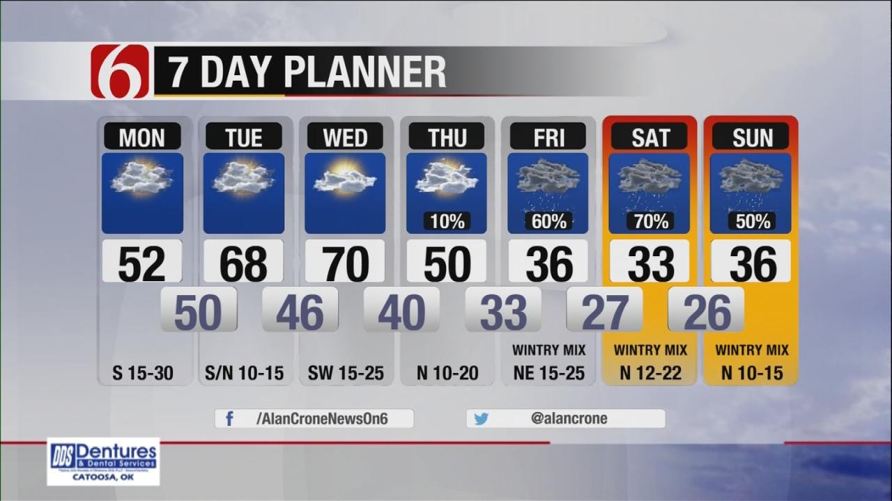
We have two issues for the week regarding our sensible weather. The first bringing strong winds and a limited fire danger, mostly to the west. The 2nd will be another arctic front with the potential for more wintry precipitation Friday into the weekend. Unfortunately, the data and this pattern, suggest the predominate precipitation type would be freezing rain or sleet near or west of the metro, with a heavy rainfall threat across southeastern OK. The data will change a few times with the specifics between now and the end of the week, but the pattern is going to support a possibility of some icing for a part of Oklahomalahoma.
Today a strong south wind will be likely with some 20 to 30 mph winds helping to create a limited fire danger issue, mostly across the western sections of the state. Despite the recent snowfall and the melt, the top layer and vegetation will remain dry. Any fires that start today would spread rapidly.
Today is not a good day to burn due the anticipation of the strong winds that will develop and continue through the night. Temperatures will mild with morning lows in the 30s-40s and highs moving into the 50s across eastern OK with some sunshine this morning and more clouds by midday to afternoon. Some patchy drizzle may be possible across eastern Ok later this afternoon and tonight as low-level moisture streams back into far eastern OK, and this should limit the fire danger issues across far eastern OK but the strong winds may still be the bigger issue.
Even warmer air will be likely Tuesday with morning lows in the 40s and highs in the upper 60s or lower 70s.
A weak front will move across the northeastern OK area Tuesday night into Wednesday morning before quickly stalling and retreating northward Wednesday afternoon with highs topping out in the lower 70s. A few isolated showers or rumbles of thunder may be possible across the extreme eastern OK area Tuesday and Thursday, but the odds will remain near or less than 10 percent.
The winds will quickly return from the south Wednesday morning to afternoon with temperatures moving back into the upper 60s or lower 70s once again for daytime highs. But the leading edge of the arctic air will arrive Thursday and move across the area Friday setting the stage for rain chances that will transition into freezing rain opportunities by Friday night into Saturday morning and midday. This morning’s data seems to be pushing the icing zone slightly more westward, indicating the shallow nature of the air mass will be struggling to penetrate to the southeast.
A true arctic front and air mass is different from a Canadian or continental air mass due to the shallow nature of the cold air. The data today (and the past few days) continue to support a shallow, arctic air mass moving into the state Friday and Saturday. Temperatures in the very lowest layer of the atmosphere will be in the upper 20s or lower to mid-30s, near or slightly below freezing, across at least part of the state, mostly along and west of the I-44 corridor region with above freezing temperatures to the southeast of this zone. This air mass may easily stall across southeastern OK as the shallow cold air may not clear the mountains or hills of southeastern OK.
Air temperatures a few thousand feet above the surface will be much warmer (above freezing) compared to the surface air. As the next storm system approaches Friday into Saturday from the southwest, moisture will be drawn up and over the shallow dome of cold air and fall from the warm layer to the surface. As the precipitation falls from the warm layer, it will be rain. But as it approaches the surface, it will encounter surface temps near or slightly below freezing and will have a chance to freeze upon contact with the surface or elevated objects.
If the cold air dome is slightly deeper and the warm air layer more elevated and smaller, there may be a chance for sleet. This seems unlikely at this point. And, based on the model runs from the last two days, the most least likely precipitation type is snow. While this forecast for some icing potential is far from “locked” for the Tulsa metro, the trend in the data does support an icing scenario for part of the weekend, near or west of the Tulsa metro with rain to the southeast. This zone of freezing surface temperatures will slide around in the data for the next few days.
We’ll be watching data and model runs very closely the next few days and make changes when necessary. We encourage you to remain aware of the forecast for the end of the week.
Thanks for reading the Monday morning weather discussion and blog.
Have a super great day!
Alan Crone
KOTV
More Like This
January 9th, 2017
January 2nd, 2025
September 29th, 2024
September 17th, 2024
Top Headlines
January 20th, 2025
January 20th, 2025
January 20th, 2025
January 20th, 2025


