Oklahoma Weather: Active Pattern Continues Over The Weekend
The weekend brings more storm chances in some locations. A stronger system arrives early next week, bringing cooler temperatures and additional rain chances to part of the area.Friday, September 19th 2025, 10:28 pm
TULSA, Okla. -
Any Rain For Saturday?
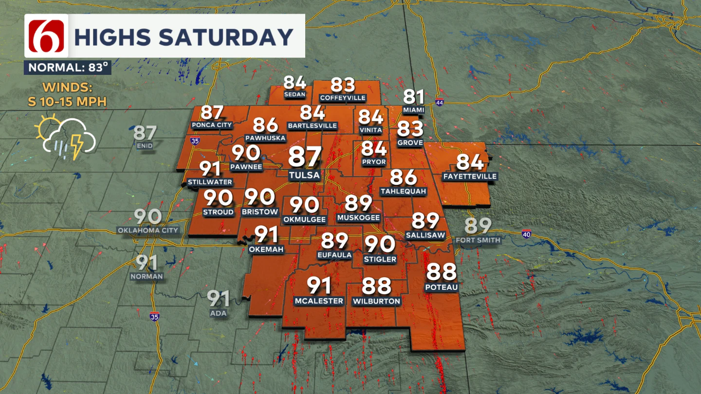
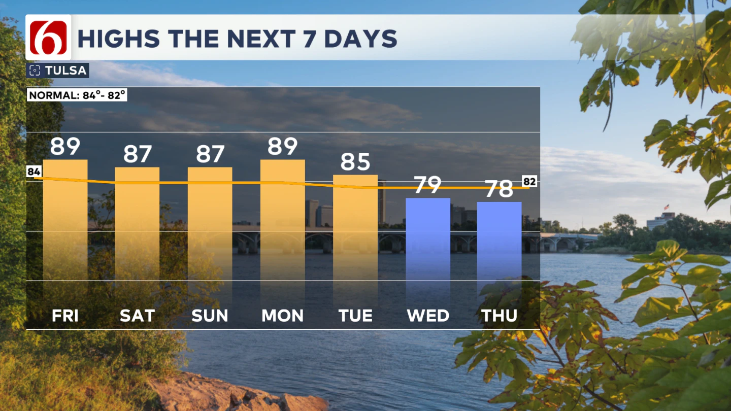
Looking ahead to Saturday, another wave of instability will approach the Central Plains. Saturday morning temperatures will start in the mid to upper 60s and climb into the mid to upper 80s under partly cloudy skies. Areas south of Tulsa may climb back into the lower 90s where storms look less likely.
Showers and storms are likely to develop across central Kansas and move southeast, influencing our southeastern Kansas and northeastern Oklahoma counties early Saturday morning.
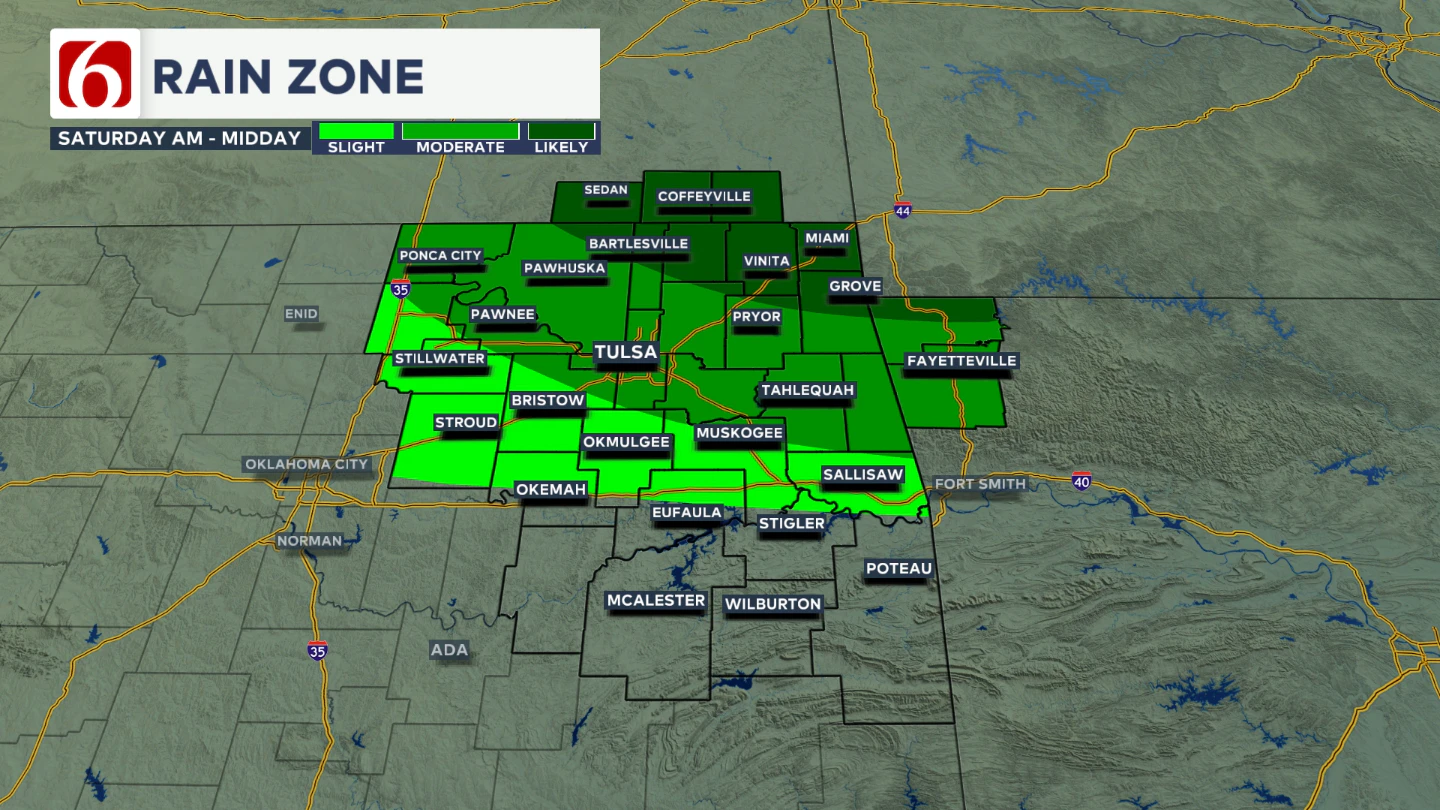
We'll have the higher probabilities for at least the first part of the day near or northeast of Tulsa. But a few additional scattered storms will remain possible later in the afternoon and at the end of the day Saturday across other portions of eastern Oklahoma.
Could Sunday Bring More Rain?
On Sunday, another upper-level wave moves in, bringing additional mentions for showers and storms across parts of the region. Similar to recent days, some locations will stay dry, but others could see some locally heavy storms.
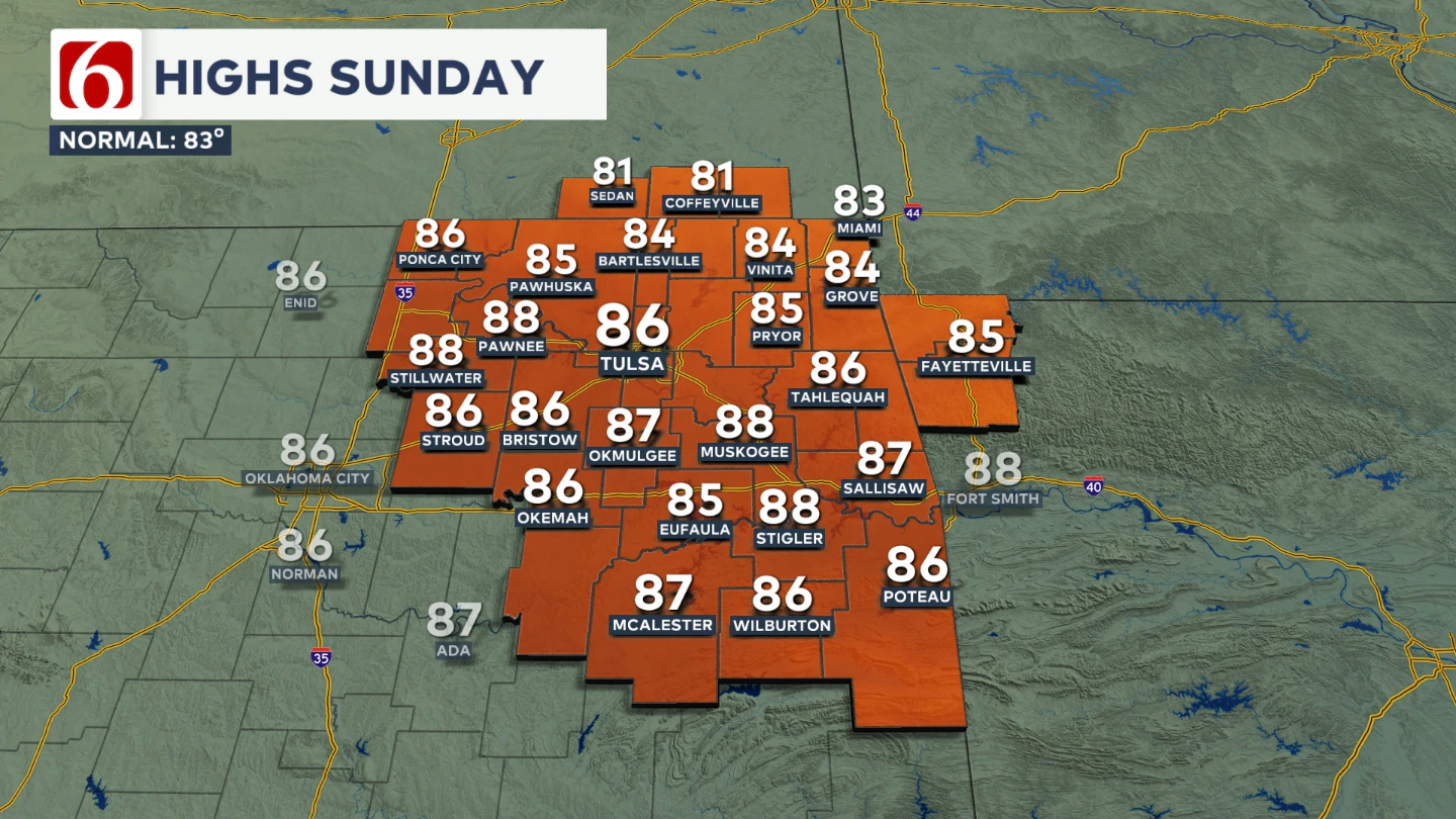
Sunday morning lows will be in the upper 60s, with highs in the mid to upper 80s.
What’s Coming Next Week?
Another pattern change is likely next week. A strong upper-level system will develop across the Central Plains and linger near our area for several days. This will bring more cloud cover and occasional showers and storms.
Additionally, a surface boundary is expected to move through sometime Tuesday or early Wednesday, which could also trigger a few storms.
Any Cool Weather Next Week?
Early next week, expect morning lows in the 60s and daytime highs gradually dropping into the upper 70s or even mid 70s for Wednesday and Thursday.
Saturday – Auburn vs. OU in Norman:
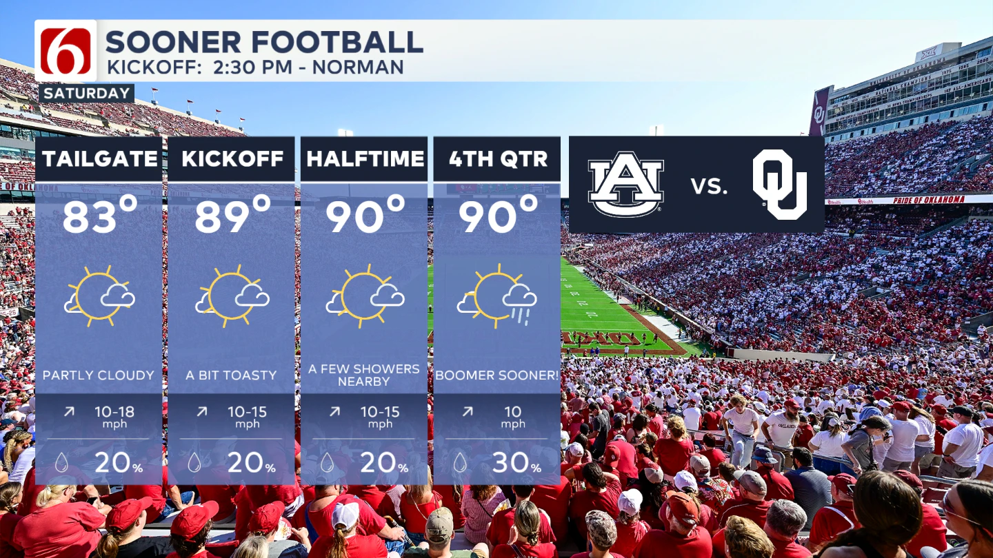
Tailgating will see temperatures climbing into the 80s by midday, with a slight chance for a few morning and midday showers.
Kickoff temps will be in the upper 80s to near 90, possibly climbing into the lower 90s during the game. Rain chances initially remain near 20%, but a slightly higher chance of storms could develop towards the end of the game. If you're planning to be in Norman, stay hydrated and just be aware that a few isolated showers or storms could eventually pop up.
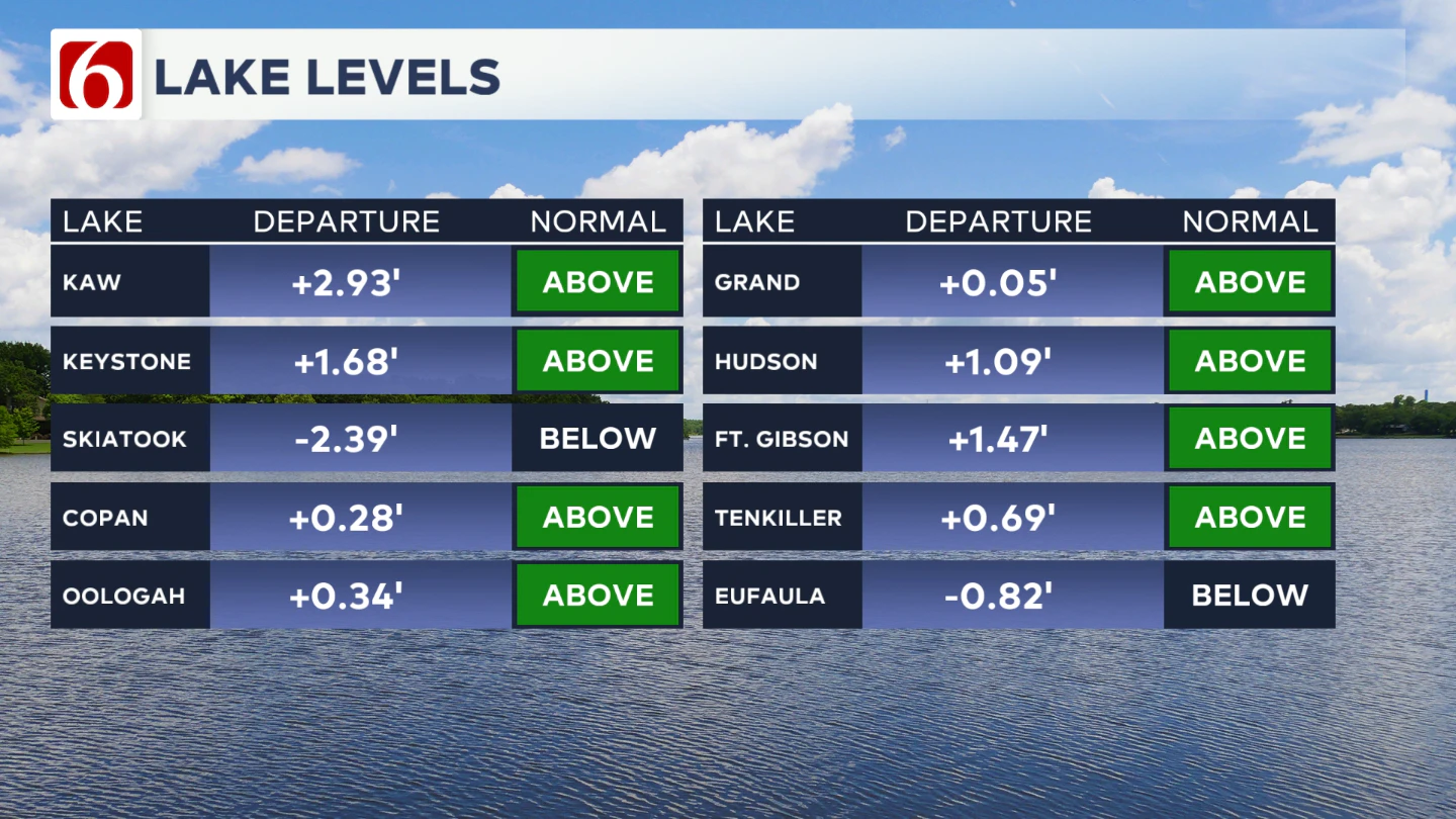
Lake Levels
If you're making some lake recreation plans, here's an update on our area lake levels. You can look up specific lake levels anytime on our website here: https://www.newson6.com/story/5e367cbd2f69d76f6208fbb6/oklahoma-lake-levels
The Illinois River Near Tahlequah
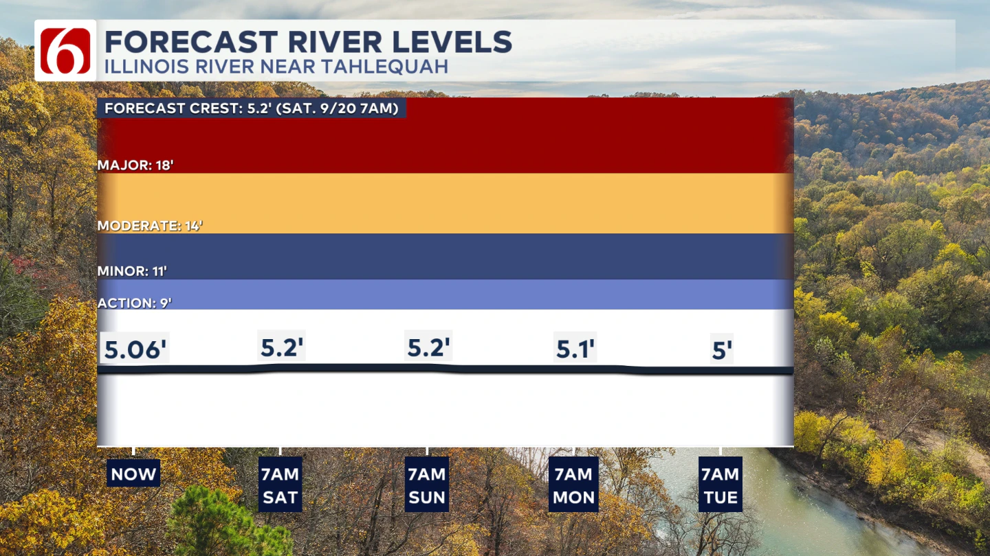
River levels should remain around 5' give or take a little bit though the next few days.
The Morning Weather Podcast:
The daily morning weather podcast briefing will remain on hold indefinitely due to ongoing internal workflow issues.
We're working to resolve these challenges as soon as possible and appreciate your patience. We apologize for the inconvenience and hope to be back soon. Thank you for your understanding.
Hot weather safety:
🔗 Oklahoma heat safety tips: How to spot and prevent heat illness
🔗 Top summer safety tips every family needs to know
🔗 'It can happen to anybody': First responders warn of hot car deaths
Need-to-know severe Oklahoma weather prep:
🔗Severe weather safety: what you need to know to prepare
🔗Tornado Watch vs. Tornado Warning: what they mean and what to do
🔗Severe weather safety: what to do before, during, and after a storm
🔗Why registering your storm shelter in Oklahoma could save your life
🔗Floodwater kills more Oklahomans than tornadoes in the last decade, here's why
🔗'Turn around, don't drown': Flood safety tips for Oklahomans
🔗5 things to know: How Oklahomans can get federal money to install storm shelters
🔗Breaking down the SoonerSafe Rebate Program: Do I qualify for a storm shelter?
Watch us on YouTube
Follow NewsOn6 on X/Twitter for automated severe weather alert posts: @NewsOn6
Emergency Info: Outages Across Oklahoma:
Northeast Oklahoma has various power companies and electric cooperatives, many of which have overlapping areas of coverage. Below is a link to various outage maps.
- PSO Outage Map
- OG&E Outage Map
- VVEC Outage Map
- Indian Electric Cooperative (IEC) Outage Map
- Oklahoma Association of Electric Cooperatives Outage Map — (Note: Several Smaller Co-ops Included)
Follow News On 6 Meteorologists on Facebook
More Like This
September 19th, 2025
September 19th, 2025
September 19th, 2025
September 19th, 2025
Top Headlines
September 19th, 2025
September 19th, 2025
September 19th, 2025
September 19th, 2025
