Summer-Like Heat, Storm Chances Kick Off Spring
<p>It only seems fitting that a winter which resembled spring would be followed by a spring that started out like summer. Mother Nature seems to be a bit ahead of herself this year. </p>Monday, March 20th 2017, 7:14 am
It only seems fitting that a winter which resembled spring would be followed by a spring that started out like summer. Mother Nature seems to be a bit ahead of herself this year. This near record warmth stands in stark contrast to last week when temperatures struggled to rise out of the lower 40s for highs on a few days. These major temperature fluctuations will continue in the week ahead and it comes with storm chances as well.
The vernal equinox is the fancy term for the beginning of spring, when the sun’s rays fall directly perpendicular to the Equator in its path to light and heat the Northern Hemisphere in greater proportion for the next 6 months.
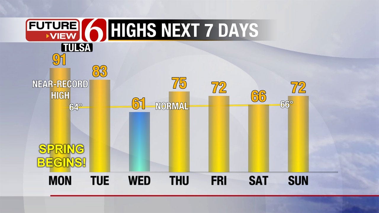
The sun will do a number on our temperatures tomorrow, in tandem with southwesterly winds ahead of our next storm system here in Oklahoma. It will push our highs into the lower 90s, nearing a record of 92° in Tulsa set 110 years ago. Instead of feeling like the first day of spring, it will feel like late June when the average high is in the lower 90s.
The warmth will stick around one more day before a frontal boundary seeps south of Tulsa Tuesday night bringing a slight chance of scattered thunderstorms and showers or drizzle by Wednesday along with a 30° drop in high-temperature readings from Monday. That front won’t settle too far south before lifting north as a warm front Thursday in response to a much stronger storm system approaching late this week.
There is already a decent amount of buzz about this upcoming storm system due to the strength of the wave and the classic severe weather set-up indicated in some of our computer models. However, it is not consistent and certainly not set in stone.
Instability and moisture may be quite marginal here in Green Country and the dry line may rush past most of our counties before peak heating. In any case, this is a powerful system that has the potential to bring storms to our area. Should the system’s orientation adjust and thus, better instability be in place, it could be a rough day for us.
Stay tuned to this threat this week, but don’t believe the hype that it’s a guaranteed severe weather outbreak for us. However it turns out, it is a good reminder that we are now entering severe weather season. Now is the time to make sure you and your loved ones are prepared for sheltering should it be necessary.
By next weekend, we’ll see a brief lull in the active weather before another wave of energy comes racing in from the west. This is part of an active pattern that will supply us with at least two more rounds of inclement weather before the end of the month.
Hopefully, this will also supply us with much-needed rain. While our vegetation is coming out of dormancy, it remains dry enough to be good fuel for wildfires. Until we receive a few good soaking rains, we aren’t clear of this rough wildfire season yet. The outlook for rainfall into early April is positive.
It also bodes well for those wanting to do some planting as a continued warmer than normal pattern will keeping freezing temperatures at bay. There’s a chance we saw the last of our freezing temperatures for the season this past week.
Enjoy the beginning of sum…err spring on Monday! I’ll keep you posted on our storm threats this week on Twitter (@GroganontheGO) and on my Facebook Page.
More Like This
March 20th, 2017
September 29th, 2024
September 17th, 2024
Top Headlines
December 17th, 2024
December 17th, 2024
December 16th, 2024


