Winter Weather Coverage Continues Across Green Country
Green Country is preparing for a winter storm on Wednesday.Wednesday, February 23rd 2022, 10:56 pm
TULSA, Oklahoma -
Winter Weather is covering most of Green Country on Wednesday and will likely continue through Thursday.
As of 8:00 p.m. on Wednesday, February 23rd, EMSA has responded to the following weather-related incidents in our Eastern Division Service Area (Tulsa Area):
- 9 Motor Vehicle Accidents
- 4 Cold Exposure Calls
- 7 Slip/Fall Calls
- 1 Carbon Monoxide Incident
Click here to watch live team coverage from News On 6.
The News On 6 digital team will be updating this story throughout the day with updates on road conditions, power outages, wrecks, and more.
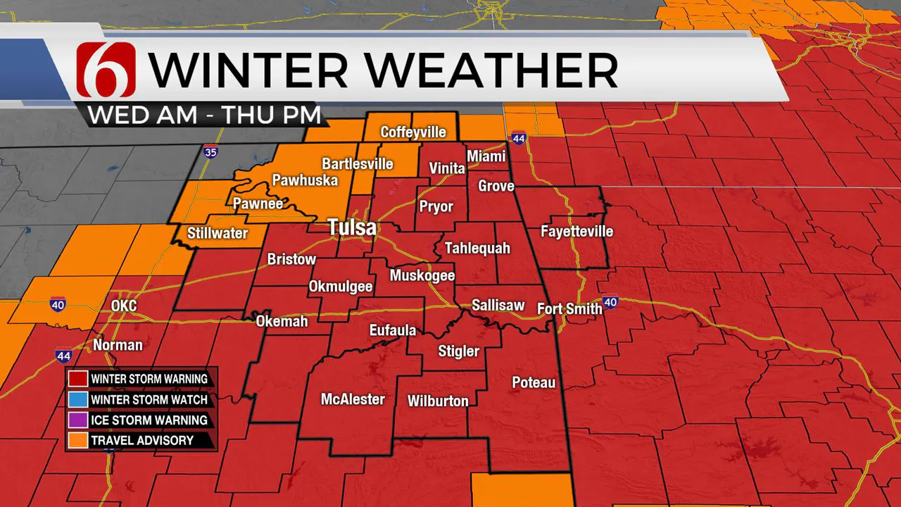
A winter storm warning has been issued for multiple counties in southeast and northeast Oklahoma.
The following counties are under the warning until 6 p.m. on Thursday, February 24:
- Adair
- Cherokee
- Craig
- Creek
- Delaware
- Haskell
- Latimer
- LeFlore
- Lincoln
- Mayes
- McIntosh
- Muskogee
- Okfuskee
- Okmulgee
- Ottawa
- Payne
- Pittsburg
- Pushmataha
- Rogers
- Sequoyah
- Tulsa
- Wagoner
Team Coverage
Related Story: City Of Tulsa Ready To Treat Streets For Snow, Ice
Related Story: ODOT Prepared To Treat Roads Once Winter Weather Begins
Related Story: Muskogee City Crews Prepped For Winter Storm
Related Story: School Closings Due To Winter Storm (Feb. 23)
StormTrackers:
News On 6's Von Castor is tracking road conditions and winter weather near McAlester.
Winter weather is moving into Green Country and it could mean dangerously cold temperatures and the threat for ice.
Here are the details from News On 6 Meteorologist Alan Crone:
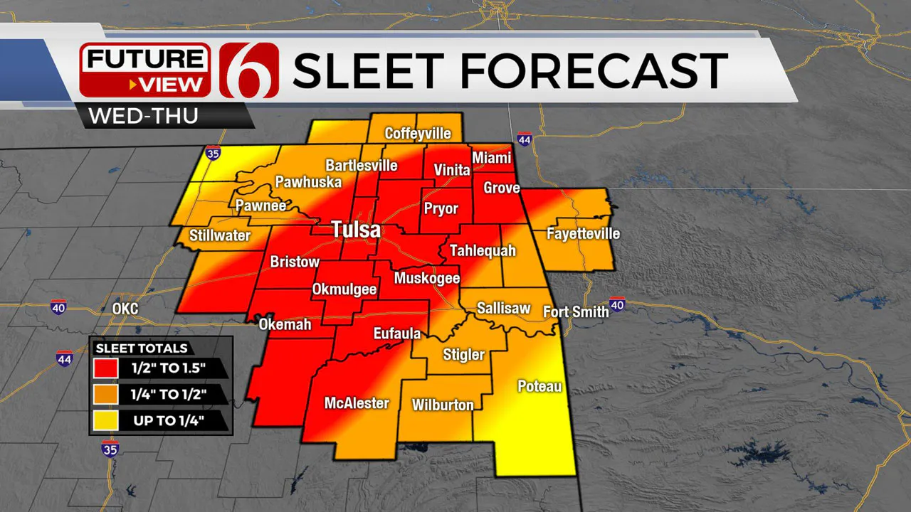
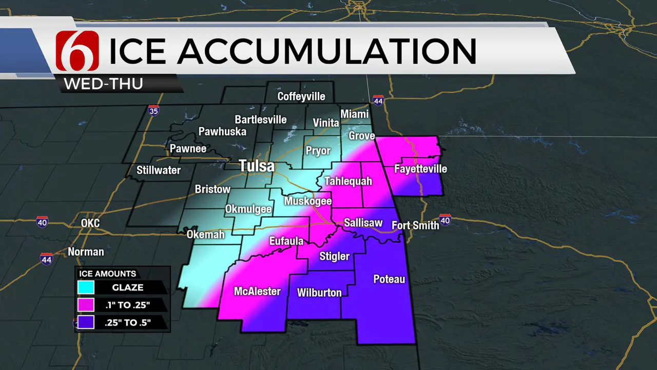
The first of two waves of wintry precipitation arrive this morning and the 2nd overnight into Thursday morning. Periods of sleet and freezing rain will be likely with this system. Pockets of moderate to heavy sleet bursts will be possible this morning to midday with the initial wave. We’ll see a relative break this afternoon and evening before the 2nd wave nears the area. Locations across southeastern and far east central OK will experience more freezing rain overnight and early Thursday morning. Some snow will also be possible at times, mostly across extreme northern OK and southern Kansas. Overall amounts of wintry mix will be near 1 to 2 inches along the metro region southward, with lower amounts to the northwest. Because impactful amounts of sleet and freezing rain will be the prominent precipitation types, a winter storm warning is underway for locations for a large portion of Northeastern OK. A winter weather advisory remains for locations northwest of I-44 and surrounding areas of southern Kansas. Winter storm warnings also remain for part of North TX. Icy roads are likely at times during this winter system. Ice accretion in trees and powerlines combined with gusty north winds may result in sporadic power outages, mostly across extreme southeastern OK and part of western Arkansas. This system is expected to exit the area Thursday midday to afternoon. Another fast and weak wave nears southern OK Saturday that may produce some light showers, but our probability will remain low.

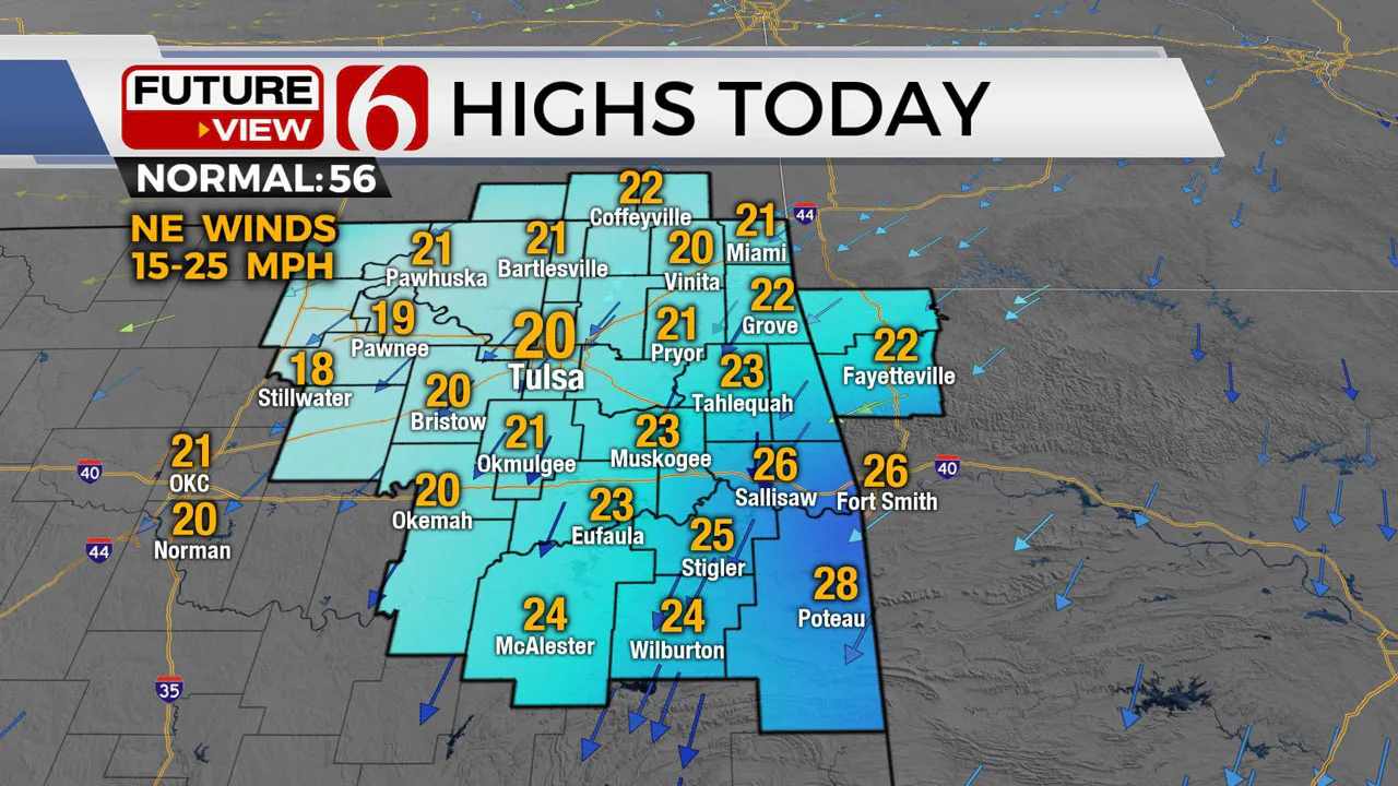
Temperatures will remain in the teens this morning and near 20 this evening with northeast winds from 15 to 25 mph. Sub-zero wind chills are likely early this morning across northern OK. Thursday morning temps in the lower 20s will rebound into the upper 20s near 30 Thursday afternoon as the system exits the area. Some locations across southeastern OK will move above freezing late tomorrow afternoon. Clear sky and light winds are likely Friday with morning lows in the teens. Friday afternoon highs may briefly exceed freezing in some locations, but we'll continue to keep the metro at 32 for this forecast update.

The weekend features morning lows well below freezing but afternoon highs Saturday in the lower 40s and Sunday into the upper 50s and lower 60s.


Remain aware of the weather both Wednesday and Thursday.
Even relatively low amounts of sleet and freezing rain can be highly problematic during travel.
Thanks for reading the Wednesday morning weather discussion and blog.
Have a super great day!
Alan Crone
KOTV

The morning podcast link: https://podcasts.apple.com/us/podcast/weather-out-the-door/id1499556141?i=1000551982996
More Like This
February 23rd, 2022
June 21st, 2023
June 19th, 2023
June 13th, 2023
Top Headlines
November 6th, 2024
November 6th, 2024
November 6th, 2024


