Relief from deep-freeze approaches as rest of week warms up
Oklahoma has been in the grip of an Arctic blast, with record-breaking low temperatures and extended freezing conditions. Meteorologist Travis Meyer explains what this means for residents and when we can expect some relief.Wednesday, January 22nd 2025, 9:44 am
TULSA, Okla. -
Oklahoma has been in the grip of an Arctic blast, with record-breaking low temperatures and extended freezing conditions.
>>> How To Prepare Your Car For Oklahoma Winter Weather
However, we will start to warm up again beginning on Wednesday.
Here is what you can expect:
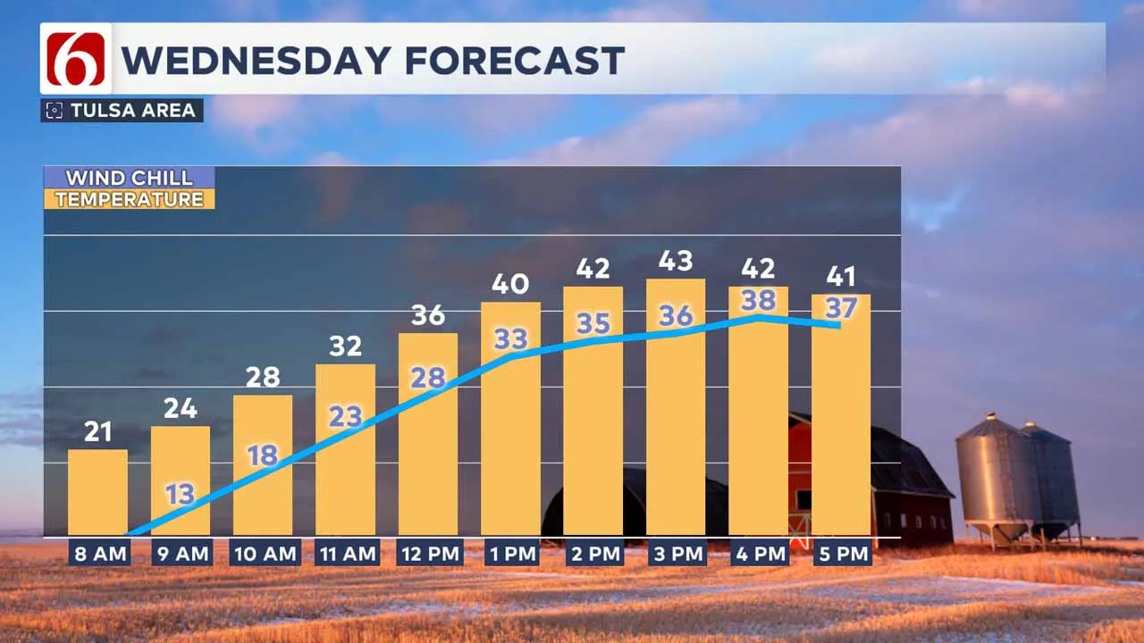
Moving Above Freezing Wednesday Afternoon
Temperatures will start in the upper teens and lower 20s Wednesday morning, but should finally move above freezing by midday, reaching the lower to mid-40s this afternoon.
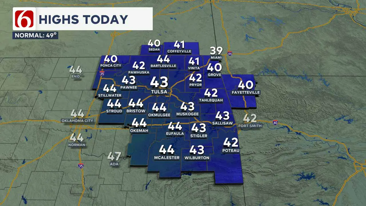
Gusty south winds are likely for the morning to midday hours before relaxing speeds as a front nears northern Oklahoma.
This front will slide across the area this afternoon and evening but will not produce any precipitation.
Gusty northwest winds will return behind the front this evening, with speeds from 15 to near 25 mph.
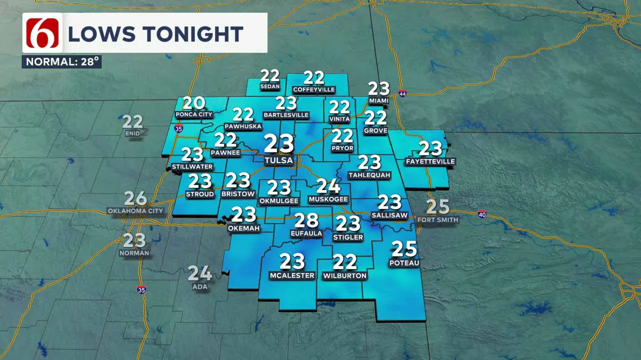
Winds will decrease overnight into early Thursday morning, with lows in the upper teens and lower 20s.
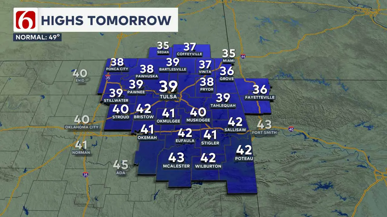
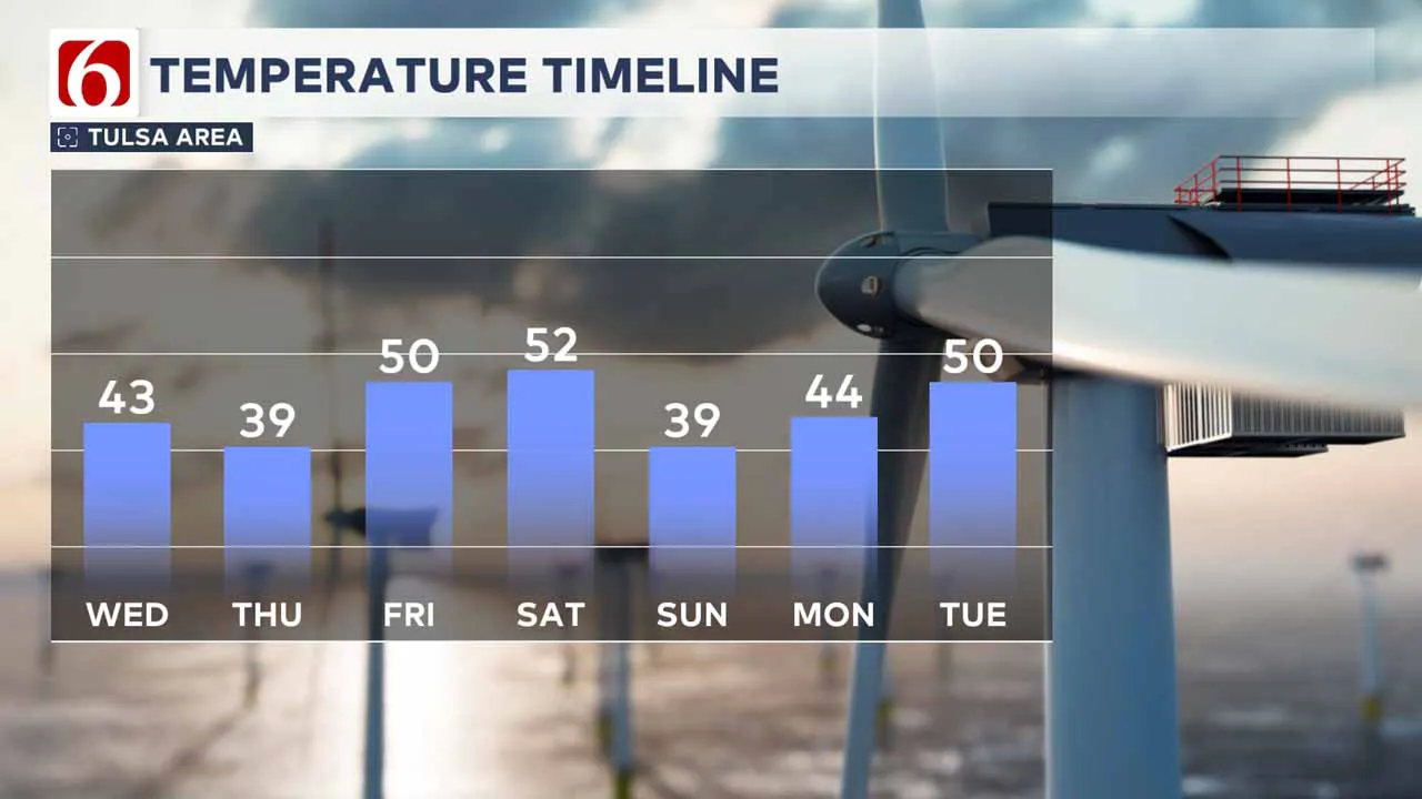
Thursday afternoon highs will stay in the upper 30s and lower 40s for most locations.
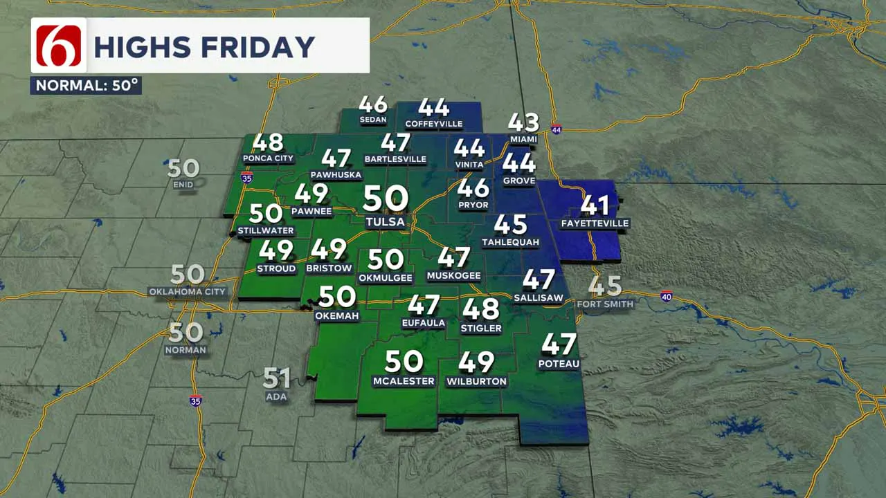
How’s the Weekend Outlook?
The next storm system will develop this weekend to our west and bring another cold front across the area late Saturday night into Sunday morning.
Pressure gradients will tighten, and strong south winds will bring some low-level moisture back into the area on Saturday, with afternoon highs reaching the lower 50s.
As the front nears, a surface area of low pressure will develop on the boundary and may enhance convergence along and ahead of the front, increasing the chance of rain across southeastern Oklahoma and western Arkansas.
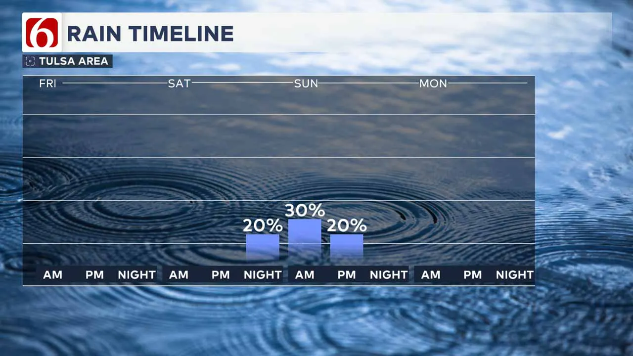
An upper-level system will also be nearing the region and may allow some colder air to move across parts of northern Oklahoma by Sunday midday to afternoon.
Depending on the exact temperature profile and timing, there may be enough cold air and moisture remaining to produce a light wintry mix.
This probability remains low and is currently not included in the forecast but is something we’ll continue to track over the next few days.
Sunday morning lows will be near or slightly below freezing with afternoon highs in the upper 30s and lower 40s.
Any Rain Next Week?
Temperatures will moderate early next week, with morning lows in the 30s and 40s followed by daytime highs in the 40s on Monday and mid to upper 50s on Tuesday and Wednesday.
There is a low chance that some locations could approach 60 by next Thursday.
An area of low pressure will develop across Southern California this weekend. This disturbance will become cut off from the upper air flow and is not expected to move eastward until the middle or later part of next week.
As the system eventually moves east, it will increase the likelihood of moisture reaching our area by mid to late next week. However, global model data is still inconsistent regarding the trajectory of the system.
Fire Spread Concerns in Southern California
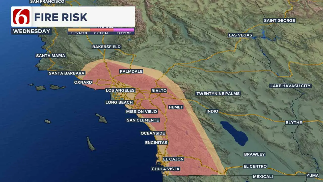
The fire spread rate continues to be a concern across southern California today and may increase even more over the next few days.
Red Flag warnings, as well as high wind warnings and advisories, remain in effect. Relative humidity near or less than 10 to 20%, combined with strong winds, will fuel ongoing fires, and support the rapid spread of any additional new fires.
Where are the warming shelters available in Tulsa this year?
The city of Tulsa, local shelters, warming stations, and outreach teams are working to ensure access to safe, warm spaces during the cold temperatures.
>>> City of Tulsa prepares for extreme cold temperatures
>>> Warming Shelters Open Across Tulsa Amid Freezing Temperatures
Tulsa shelters and temporary warming locations are open to provide refuge. Major locations include:
- John 3:16 Mission, 506 N. Cheyenne — Open 24/7
- The Salvation Army Center of Hope, 102 N. Denver Ave. — Open 24/7
- Tulsa Day Center, 415 W. Archer St. — Open 24/7 (Pets allowed, limited capacity)
- Youth Services of Tulsa, 311 S. Madison Ave.
Temporary overflow shelters will also be open for the cold weather:
- The Merchant: 605 S. Peoria Ave., open Monday, Jan. 20, 9 a.m.–Noon; Tuesday-Friday, 9–11 a.m.
- Denver Avenue Station: 319 S. Denver Ave., open Sunday, 8:30 a.m.–8:30 p.m.; Monday-Saturday, 5:30 a.m.–11:30 p.m.
- The Station at Youth Services: 311 S. Madison Ave., open Monday-Friday, 11 a.m.–4 p.m.
- Iron Gate: 501 W. Archer St., open daily, 8:30–10:30 a.m.
- The Ministry Center: 312 S. 33rd W. Ave., open Tuesday-Thursday, 9:30 a.m.–1 p.m.
For a full list of warming station locations and hours, visit Housing Solutions’ Winter Weather Information Page.
>>> Warming Shelters, Safety Tips For Cold Temperatures This Winter In Oklahoma
Bring Pets Inside!
Winter temperatures can pose additional challenges for pets, particularly older animals or those with health conditions. Hartfield recommends:
- Wellness Checks: Ensure pets are up to date on vaccines and discuss arthritis or other cold-weather health concerns with a veterinarian.
- Outdoor Time: Monitor the duration of outdoor activities, especially for short-haired breeds or pets with conditions like diabetes or heart disease.
- Paw Care: After walks, inspect and clean paws to remove ice or de-icing chemicals that could harm your pet.
>>> Cold Weather Pet Tips: How To Keep Animals Safe During Winter Months
How Can I Protect Myself From Sickness This Winter?
The Tulsa Health Department is urging residents to receive flu and COVID-19 vaccinations to prevent respiratory illnesses as Oklahoma enters the coldest months of the year.
- Health experts say the risk of respiratory illnesses is higher during the winter, as colder weather often leads to more indoor gatherings, increasing the likelihood of viruses spreading.
- The Centers for Disease Control and Prevention says Oklahoma is one of 11 states with very high respiratory virus activity, and with flu vaccination rates lower than this time in 2024, more people have reported getting sick.
>>> How to Protect Yourself From Respiratory Illness This Winter
Emergency Info: Outages Across Oklahoma:
Northeast Oklahoma has various power companies and electric cooperatives, many of which have overlapping areas of coverage. Below is a link to various outage maps.
>>> Tulsa HVAC, Plumbing Companies Flooded With Calls During Cold Weather
- PSO Outage Map
- OG&E Outage Map
- VVEC Outage Map
- Indian Electric Cooperative (IEC) Outage Map
- Oklahoma Association of Electric Cooperatives Outage Map — (Note Several Smaller Co-ops Included)
The Alan Crone morning weather podcast link from Spotify:
https://open.spotify.com/episode/2eDAtzesS955BQMI54fR2e
The Alan Crone morning weather podcast link from Apple:
Follow the News On 6 Meteorologists on Facebook!
- Meteorologist Travis Meyer
- Meteorologist Stacia Knight
- Meteorologist Alan Crone
- Meteorologist Stephen Nehrenz
- Meteorologist Aaron Reeves
- Meteorologist Megan Gold

More Like This
January 22nd, 2025
January 22nd, 2025
January 22nd, 2025
January 22nd, 2025
Top Headlines
January 22nd, 2025
January 22nd, 2025
January 22nd, 2025
January 22nd, 2025


