Pleasant Conditions Arrive Across Northeastern Oklahoma
Oklahoma Weather Forecast: Bookmark this page and refresh it often for the latest forecast and daily updates.Thursday, May 9th 2024, 9:46 am


TULSA, Okla. -
Our weather pattern brings a break in precipitation for most of northeastern Oklahoma for the next few days, including most of the weekend. Near or below seasonal average temperatures are likely for daytime highs.
No severe weather threats are anticipated across northeastern Oklahoma until early next week. A few showers may populate areas near and south of I-40 this afternoon with higher chances along the Red River Valley for a few strong to near severe thunderstorms.
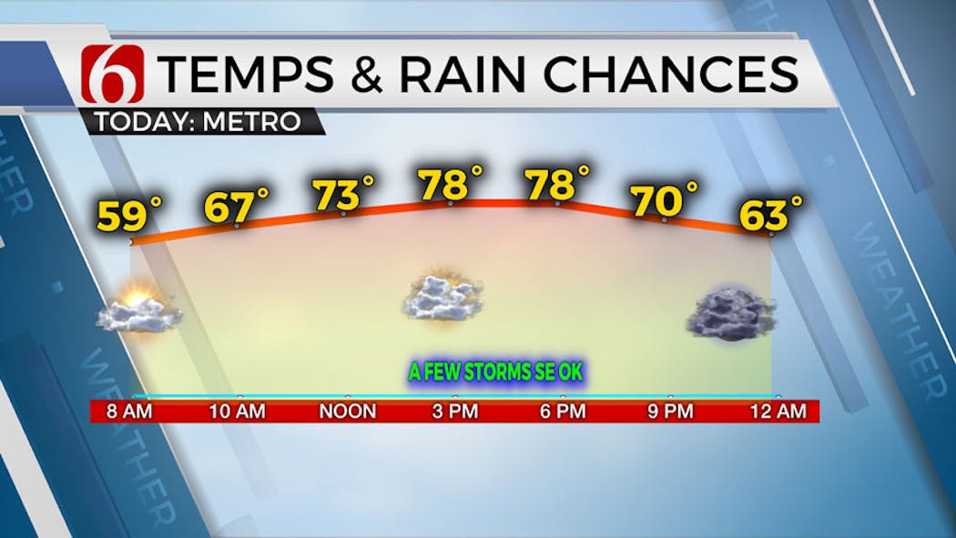
What will the weather be like in Oklahoma on Thursday, May 9?
The front has cleared the area bringing much drier and seasonal conditions to the northern two-thirds of the state. We’ll expect highs in the upper 70s across the northern sections and near 80 across southern Oklahoma.

A disturbance located across Texas will spread additional thunderstorms near the Red River Valley Thursday afternoon and a few showers or storms may move into far southeastern OK this afternoon and evening.

Severe weather threats will be likely along both sides of the Red River with a higher probability of severe storms across north Texas.
What will the weather be like this weekend in Oklahoma?
Pleasant weather remains Friday through most of the weekend with morning lows in the lower 50s and afternoon highs in the mid 70s Friday and into the upper 70s and lower 80s this weekend. Most of the weekend will remain precip free across the eastern third of the state.
A slight chance of a few showers or storms arrives Sunday afternoon as a weak midlevel disturbance approach from the west. This will bring increasing rain and thunder chances by Sunday evening into part of Monday as the upper-level feature moves across the state.
The flow is not exceptionally strong but increasing low-level moisture combined with some modest instability may still yield a threat for a few strong thunderstorms across part of the area Monday.

By the middle of next week, a stronger mid to long wave trough also nears the state bringing stronger flow across the southern and central plains.
This pattern supports increasing thunderstorms mentions Wednesday evening into Thursday before another front arrives with another potential cool-down the following weekend.
Outages Across Oklahoma:
Northeast Oklahoma has various power companies and electric co-operatives, many with overlapping areas of coverage. Below is a link to various outage maps.
Indian Electric Cooperative (IEC) Outage Map
Oklahoma Association of Electric Cooperatives Outage Map - (Note Several Smaller Co-ops Included)
The Alan Crone morning weather podcast link from Spotify:
https://open.spotify.com/episode/5j0ovActG8BZCOTqZQzrfU
The Alan Crone morning weather podcast link from Apple:
https://podcasts.apple.com/us/podcast/weather-out-the-door/id1499556141?i=1000646589555
Follow the News On 6 Meteorologists on Facebook!


Get The Daily Update!
Be among the first to get breaking news, weather, and general news updates from News on 6 delivered right to your inbox!
More Like This

May 9th, 2024

May 9th, 2024


May 9th, 2024
Top Headlines
May 9th, 2024

May 9th, 2024