Weather Blog: Summer Returns Before Our Next Fall Front
Oklahoma Weather Forecast: Bookmark this page and refresh it often for the latest forecast and daily updates.Friday, October 11th 2024, 5:57 am
TULSA, Okla. -
Some early morning showers and storms will continue on Friday across parts of east and southeast Oklahoma through the early pre-dawn hours before weakening.
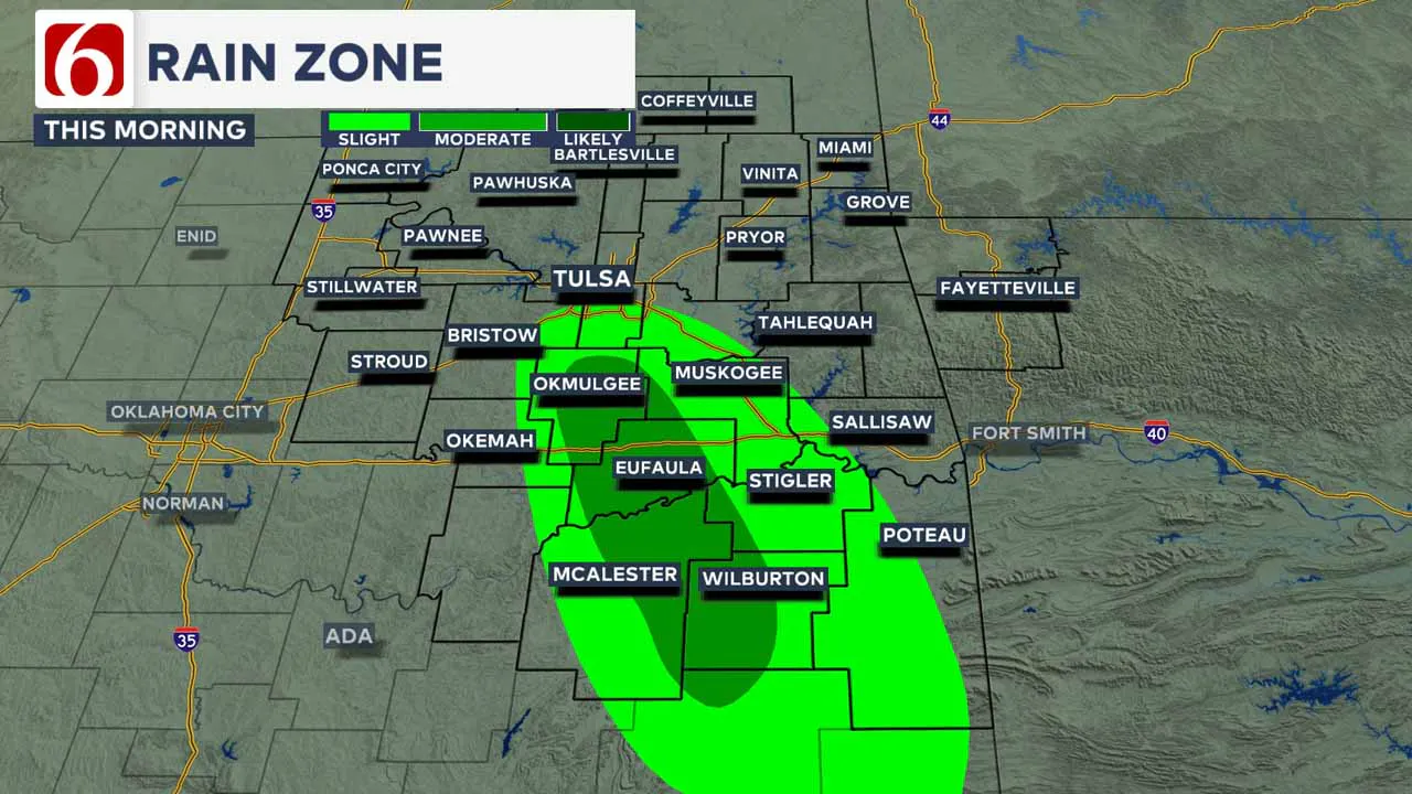
These storms are fueled by modest mid-level moisture combined with the low-level jet and upper airflow from the northwest.
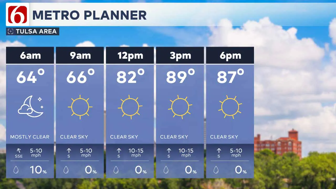
What is the weather like on Friday?
Most of the area will remain rain-free early this morning. Clouds will begin to thin out, with more sunshine midday through early afternoon.
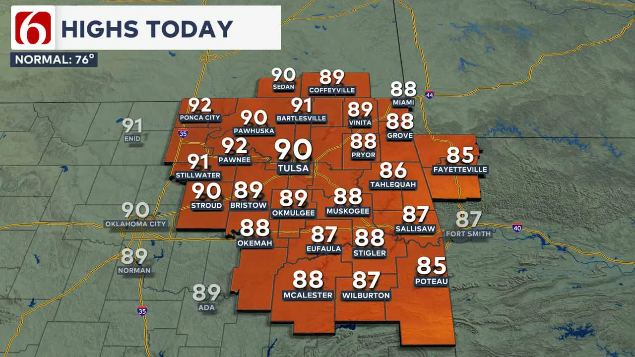
Highs will reach the upper 80s and lower 90s across eastern Oklahoma with sunshine and south winds at 10 to 20 mph.
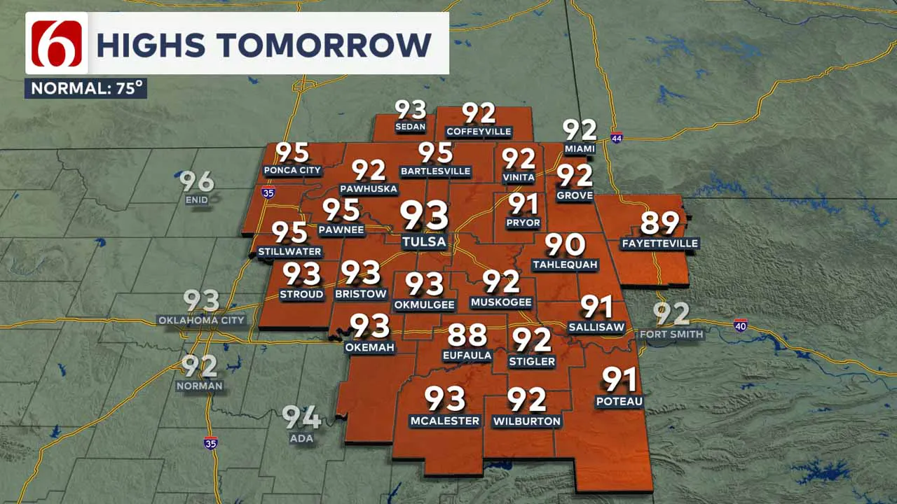
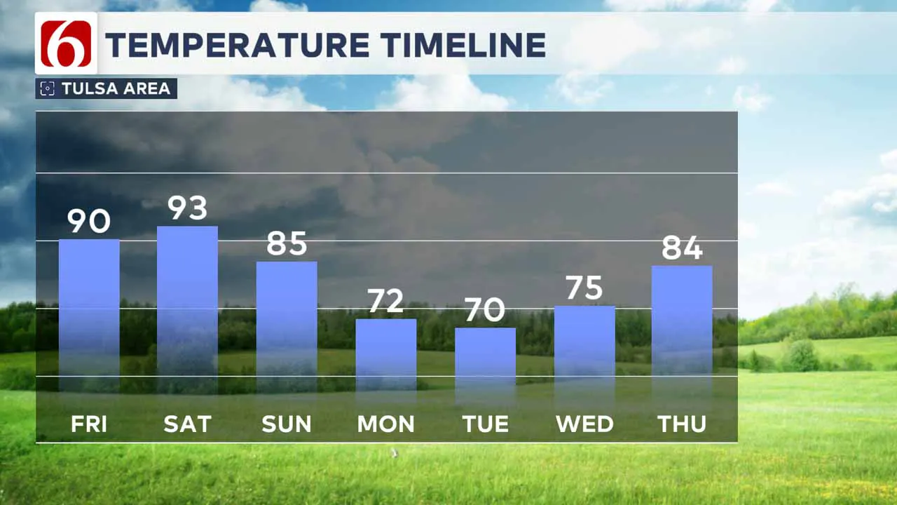
The big warm-up continues into Saturday with daytime highs in the lower to mid-90s for most of northeastern Oklahoma, with some locations across the southwestern part of the state nearing 100 degrees.
The upper air pattern undergoes significant changes this weekend, bringing a fall front into the area on Sunday.
A strong upper-level trough is developing across south-central Canada and will deepen as it moves into the Great Lakes area tomorrow. By Sunday, this trough will amplify across the far northeastern sections of the nation.
At the surface, a strong boundary will develop across the central plains and move southward Saturday night and early Sunday morning.
This front will cross northern Oklahoma Sunday morning, bringing north winds at 10 to 20 mph and slowly dropping temperatures.
Sunday’s highs are still expected in the lower to mid-80s north and near 90 south before cooler weather arrives Sunday night and early Monday morning.
The latest positioning of the upper-level trough is more to the east compared to previous runs. This means just a glancing blow of cooler, fall-like air for the middle part of the week.
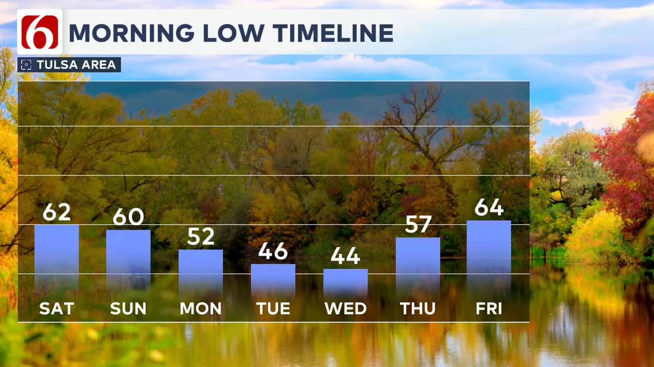
This will be notable compared to recent temperatures. Monday morning lows will start in the upper 40s and lower 50s, with daytime highs in the lower 70s.
Gusty northeast winds at 10 to 25 mph will persist through Monday with sunshine and a few clouds. A surface ridge of high pressure settles across portions of the mid-Missouri Valley Tuesday, bringing morning lows in the mid-40s in the metro, with slightly cooler locations in valleys of far northeastern Oklahoma.
Daytime highs on Tuesday have continued to trend up in some data, with many locations now in the lower 70s.
Wednesday morning starts with temperatures in the lower 40s and daytime highs in the mid-70s with sunshine and south winds at 10 to 15 mph.
The upper air pattern undergoes additional changes by the middle of next week, bringing some shower and storm chances next weekend.
Wednesday and Thursday feature a temporary mid-level ridge expanding from Texas into northern Oklahoma, bringing another few days of above-normal temperatures, with Thursday and Friday’s afternoon highs expected in the mid-80s.
A strong upper-level trough will develop across the Alberta region of Canada Wednesday and Thursday and move eastward Friday morning.
At the base of this trough, another disturbance will develop and move across portions of the central and southern plains next Saturday night, bringing another surface boundary across Oklahoma.
While we’re a full week away, most data suggest this boundary will have an opportunity for showers and thunderstorms.
Specific timing will be adjusted as we grow closer to the period, but most data suggest shower and storm chances increasing Saturday afternoon through early Sunday morning.
The upper air flow should become more progressive based on the pattern, bringing additional showers and storm chances across eastern and southern Oklahoma through the latter half of the
Football Forecast:
Friday night high school football will kick off in the lower-80s and finish the games into the lower or mid-70s.
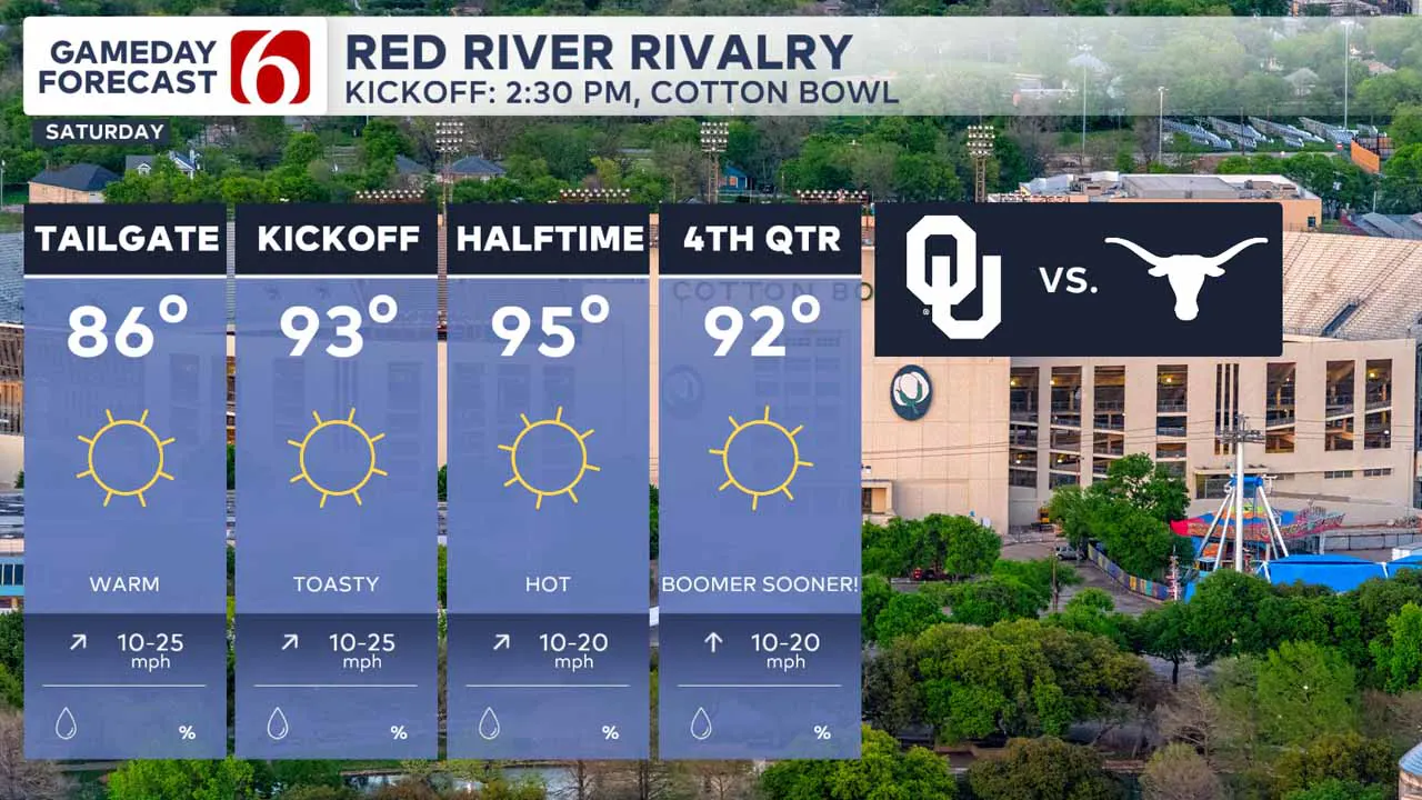
The kickoff for the Red River Rivalry between the Oklahoma Sooners and the Texas Longhorns is unchanged: Hot weather expected in the Cotton Bowl with temperatures in the lower 90s.
The Oklahoma State Cowboys and the Tulsa Golden Hurricane are not scheduled to play opponents this weekend.
Update on Hurricane Milton:
Hurricane Milton made landfall across the coastal areas of Florida Wednesday night. For the very latest, please see advisories from the National Hurricane Center.
RELATED STORY: LIVE UPDATES: Hurricane Milton Moves Offshore After Pummeling Florida
What are the major traffic projects around Tulsa this week?
The Oklahoma Department of Transportation (ODOT) and Oklahoma Turnpike Authority (OTA) provide daily details on several traffic advisories for the Tulsa area and surrounding regions.
To start October, here are some of the significant traffic advisories. For more information, see our detailed list.
I-244 Pavement Rehabilitation
- Ongoing pavement work between I-44 and the Arkansas River bridge, with lane and ramp closures lasting through spring 2025.
US-75 Bridge Rehabilitation
- Lane closures at 7th St. and off-ramp closures to 7th St. through fall 2024 for bridge rehabilitation.
US-412 Bridge Rehabilitation
- US-412 narrowed to two lanes at 81st W. Ave. in Sand Springs through February 2025.
Turnpike Ramp Closures
- Nightly ramp closures on the Will Rogers Turnpike for cashless tolling construction through Saturday.
Emergency Info: Outages Across Oklahoma:
Northeast Oklahoma has various power companies and electric cooperatives, many of which have overlapping areas of coverage. Below is a link to various outage maps.
Indian Electric Cooperative (IEC) Outage Map
Oklahoma Association of Electric Cooperatives Outage Map — (Note Several Smaller Co-ops Included)
The Alan Crone morning weather podcast link from Spotify:
https://open.spotify.com/show/0dCHRWMFjs4fEPKLqTLjvy
The Alan Crone morning weather podcast link from Apple:
https://podcasts.apple.com/us/podcast/weather-out-the-door/id1499556141?i=1000672483482
Follow the News On 6 Meteorologists on Facebook!

More Like This
October 11th, 2024
October 11th, 2024
October 11th, 2024
Top Headlines
October 11th, 2024
October 11th, 2024
October 11th, 2024
October 11th, 2024


