Temps Rebound Ahead Of Cold Front Thursday Night
Oklahoma Weather Forecast: Bookmark this page and refresh it often for the latest forecast and daily updates.Thursday, January 2nd 2025, 5:25 am
TULSA, Okla. -
Temperatures will briefly return above normal on Thursday before a cold front moves across northern Oklahoma in the afternoon.
What is the weather like on Thursday?
This front will move through the area dry but will produce mid-level clouds and northwest winds at 10 to 20 mph.
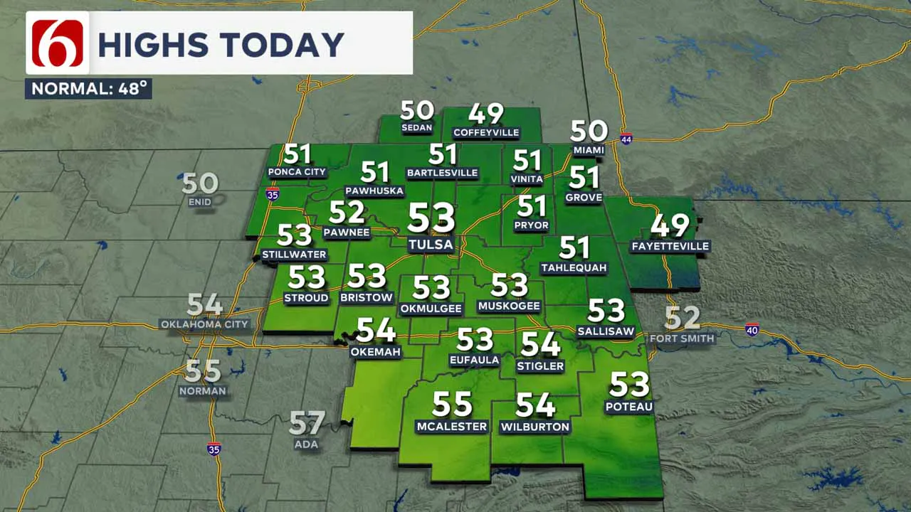
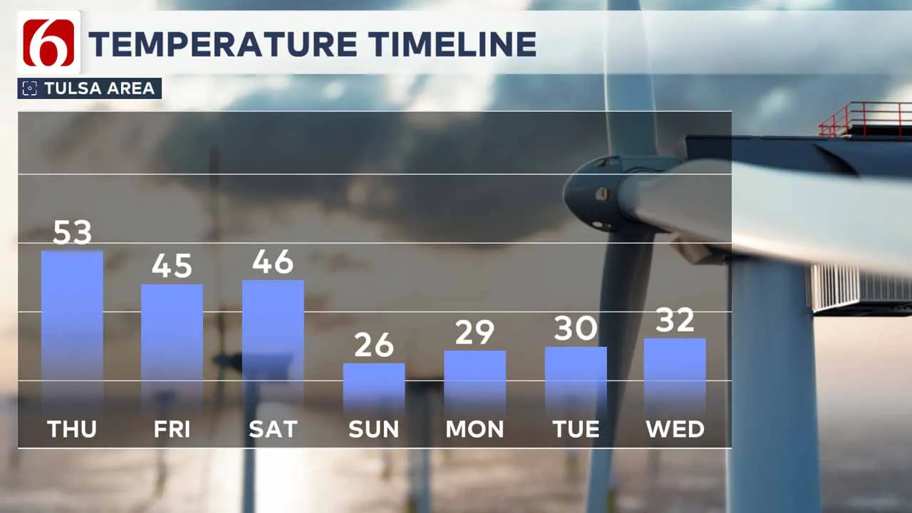
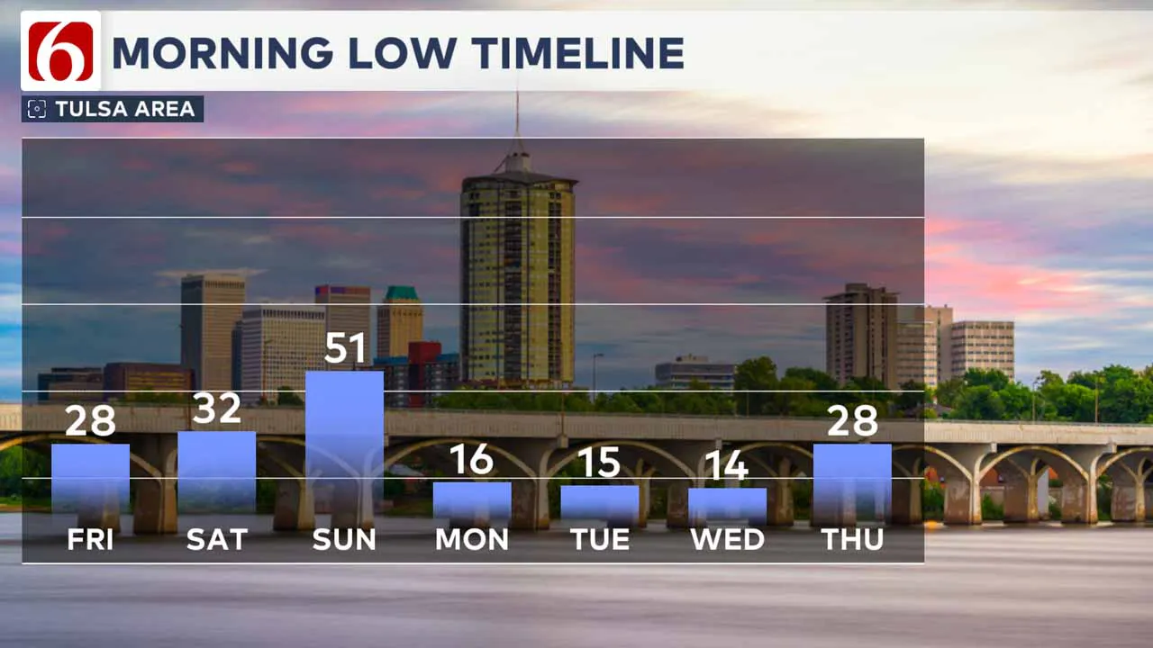
Below-normal temperatures will return on Friday, with morning lows in the mid to upper 20s and daytime highs in the mid-40s.
Mostly sunny conditions are expected on Friday with northeast winds at 7 to 12 mph.
Arctic Air Set to Arrive This Weekend
A pattern change is likely this weekend, with Arctic air arriving on Sunday and lasting through next week. Additionally, a strong storm system will bring some wintry weather impacts across parts of far northern Oklahoma, southern Kansas, southwestern Missouri, and northwestern Arkansas on Sunday.
Some light wintry weather impacts are possible near and slightly north of the Tulsa metro area.
While higher wintry impacts are likely to remain north, a slight shift in the storm system to the south could bring higher impacts through parts of northern Oklahoma.
Much colder weather will arrive throughout the day on Sunday, bringing a prolonged period of below-freezing temperatures for the early to middle part of next week.
Cloudy And Drizzly Saturday As System Approaches
Our main upper-level system of interest remains across the Pacific this morning. This system will approach the central and southern plains states on Saturday night and Sunday morning.
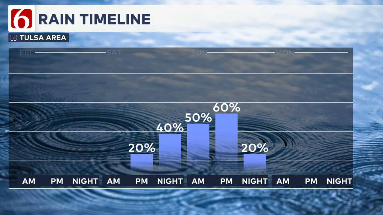
In response, Saturday we’ll see cloudy conditions, south winds at 10 to 20 mph, and increasing chances for light showers or drizzle by midday through the afternoon.
Saturday morning temperatures will start near or slightly below freezing but should rise into the mid-40s by midday into the afternoon.
Blustery And Possible Wintry Conditions On Sunday
By Sunday morning, as the main upper-level system nears the state, a very strong surface low-pressure area will develop across far northwestern Oklahoma.
This surface low is expected to rapidly move eastward on Sunday. Temperatures ahead of this feature could be as high as the 40s and 50s but will quickly drop below freezing as it passes eastward by Sunday midday to afternoon with strong northwest winds from 15 to 30 mph.
Showers and even some thunder will be possible on Sunday morning along and ahead of the front, mostly across the eastern third of the state. Behind the system, as colder weather filters southward, rain will begin changing over to some wintry weather.
Freezing rain is a possibility across far southeastern Kansas, extending into southwestern Missouri early Sunday morning.
As deeper and colder air arrives, precipitation will change to snow across southern Kansas into eastern Kansas and western Missouri from Sunday midday through the afternoon.
The current trajectory of this system suggests a dry slot will work across northeastern Oklahoma throughout the day on Sunday and quickly end precip chances for most of eastern Oklahoma.
Nonetheless, a chance of some low-end wintry weather impacts will still be included in our forecast near and north of the Tulsa metro area by midday Sunday.
Colder Temperatures and Wind Chills Next Week
By late Sunday afternoon, temperatures will drop into the mid-20s. The Arctic air should remain entrenched across most of northern Oklahoma for most of next week.
Morning lows from Monday through Wednesday will be in the mid-teens, with daytime highs in the upper 20s to near 30.
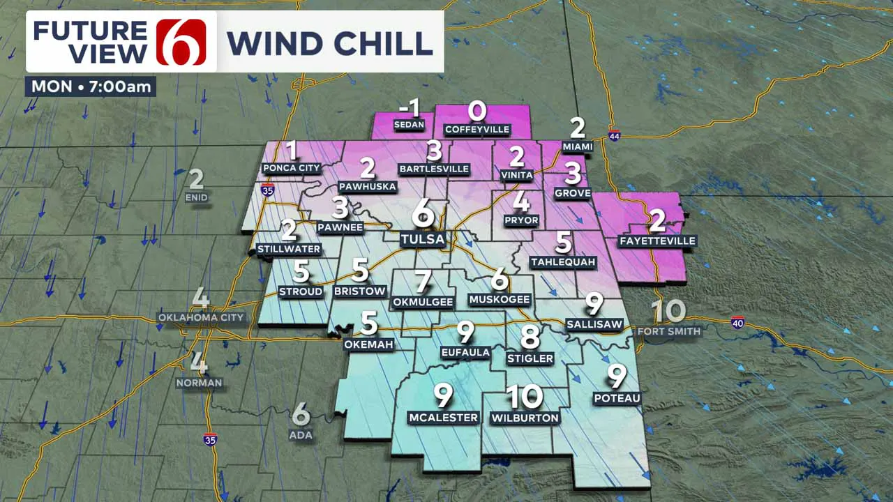
Wind chill values on Monday morning will be near 5 to 10°F. Afternoon wind chills will be in the upper teens to lower 20s.
Emergency Info: Outages Across Oklahoma:
Northeast Oklahoma has various power companies and electric cooperatives, many of which have overlapping areas of coverage. Below is a link to various outage maps.
Indian Electric Cooperative (IEC) Outage Map
Oklahoma Association of Electric Cooperatives Outage Map — (Note Several Smaller Co-ops Included)
The Alan Crone morning weather podcast link from Spotify:
https://open.spotify.com/show/0dCHRWMFjs4fEPKLqTLjvy
The Alan Crone morning weather podcast link from Apple:
Follow the News On 6 Meteorologists on Facebook!

More Like This
January 2nd, 2025
January 2nd, 2025
January 2nd, 2025
January 2nd, 2025
Top Headlines
January 2nd, 2025
January 2nd, 2025
January 1st, 2025
January 1st, 2025


