Weather Blog: Frost Flowers, Cool Temps, And A Weekend Warm-Up
Oklahoma Weather Forecast: Bookmark this page and refresh it often for the latest forecast and daily updates.Friday, November 29th 2024, 9:56 pm
TULSA, Okla. -
Tonight: Clear and Cool
It’s been a chilly Black Friday, with temperatures starting in the 20s and rising to the upper 40s and low 50s this afternoon. Tonight, Tulsa sits at 41°F, with surrounding areas dipping into the upper 30s. Light south winds at 10 mph will keep the air dry, so you might notice dry skin, chapped lips, and static hair.
Saturday: A Mild Day Before a Front
Morning: Low to mid-30s with passing clouds.
Afternoon: Highs climb to the mid to upper 50s. Winds will pick up ahead of a weak front, gusting up to 25 mph.
Sunday: Frosty Start and Sunshine
Morning: Temperatures drop back into the 20s, with potential wind chills in the teens. Areas of freezing fog could develop, creating slick spots on elevated surfaces.
Afternoon: Highs in the upper 40s under clear skies and light winds.
Next Week: A Brief Warm-Up
Monday: Upper 40s with another front bringing a return of north winds.
Midweek: Highs soar into the 60s by Wednesday before cooling back to seasonable temperatures by the weekend.
Weekend Recap
Hanging Christmas lights? Saturday offers milder conditions with a breezy south wind. Sunday will be colder but calm and sunny—just layer up!
Frost Flowers Delight Early Risers
Friday morning brought a rare sight in parts of Oklahoma—frost flowers. These delicate formations occur when warm soil pushes moisture through plant stems, freezing them into intricate shapes. Thanks to Sequoyah Quinton, one of our storm trackers, for sharing this unique phenomenon!

---
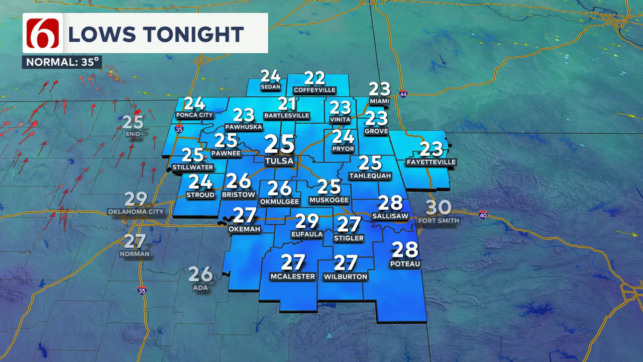
A surface ridge of high pressure nearby early Friday morning will bring cold temperatures in the lower and mid-20s. Black Friday shoppers will want to bundle up before heading out to those sales.
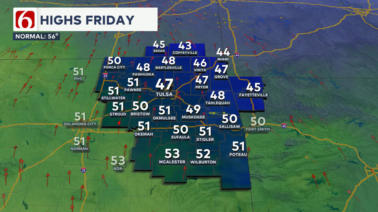
Friday afternoon will feature sunshine and light winds, with daytime highs in the upper 40s.
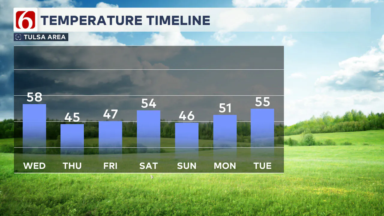
Another front will approach the area Saturday afternoon, bringing gusty north winds and falling temperatures for the rest of the weekend. Saturday morning temperatures will start in the 40s, with daytime highs approaching the upper 50s.
Gusty north winds and increasing clouds will move across southern Kansas and northern Oklahoma. A weak upper-level disturbance trailing behind the front could produce a few areas of light snow showers across eastern Kansas into western Missouri. Most, if not all, of this activity will remain northeast of our immediate area.
By early Saturday afternoon and evening, colder weather will return as temperatures drop quickly from the 50s into the 40s.
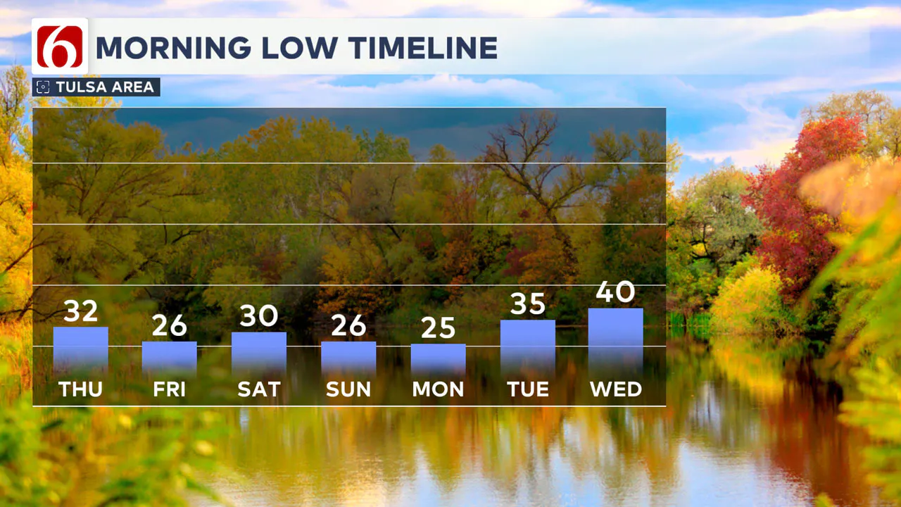
Sunday morning will start with another hard freeze, with temperatures in the mid-20s and daytime highs only in the lower 40s. We anticipate mostly sunny conditions on Sunday with a light breeze.
What is the forecast for next week?
Similar conditions are likely on Monday, with morning lows in the lower to mid-20s and daytime highs in the upper 40s to lower 50s.
A southern stream system brings some rain chances into north Texas early next week. A few of these showers may move into southeastern Oklahoma Monday evening or Thursday but probabilities remain low.
Emergency Info: Outages Across Oklahoma:
Northeast Oklahoma has various power companies and electric cooperatives, many of which have overlapping areas of coverage. Below is a link to various outage maps.
Indian Electric Cooperative (IEC) Outage Map
Oklahoma Association of Electric Cooperatives Outage Map — (Note Several Smaller Co-ops Included)
The Alan Crone morning weather podcast link from Spotify:
https://open.spotify.com/show/0dCHRWMFjs4fEPKLqTLjvy
The Alan Crone morning weather podcast link from Apple:
Follow the News On 6 Meteorologists on Facebook!

More Like This
November 29th, 2024
November 29th, 2024
November 29th, 2024
November 29th, 2024
Top Headlines
November 29th, 2024
November 29th, 2024
November 29th, 2024
November 29th, 2024

