Weather Blog: Severe Storm Chances With Wind, Hail And Tornado Threats Return Wednesday
Oklahoma Weather Forecast: Bookmark this page and refresh it often for the latest forecast and daily updates.Tuesday, October 29th 2024, 11:01 pm
TULSA, Okla. -
After a day of strong winds and wildfires on Tuesday, relief is on the way.
A storm system forecasted to track across Oklahoma on Wednesday should help ease drought conditions, but it also brings with it the chance for severe weather.
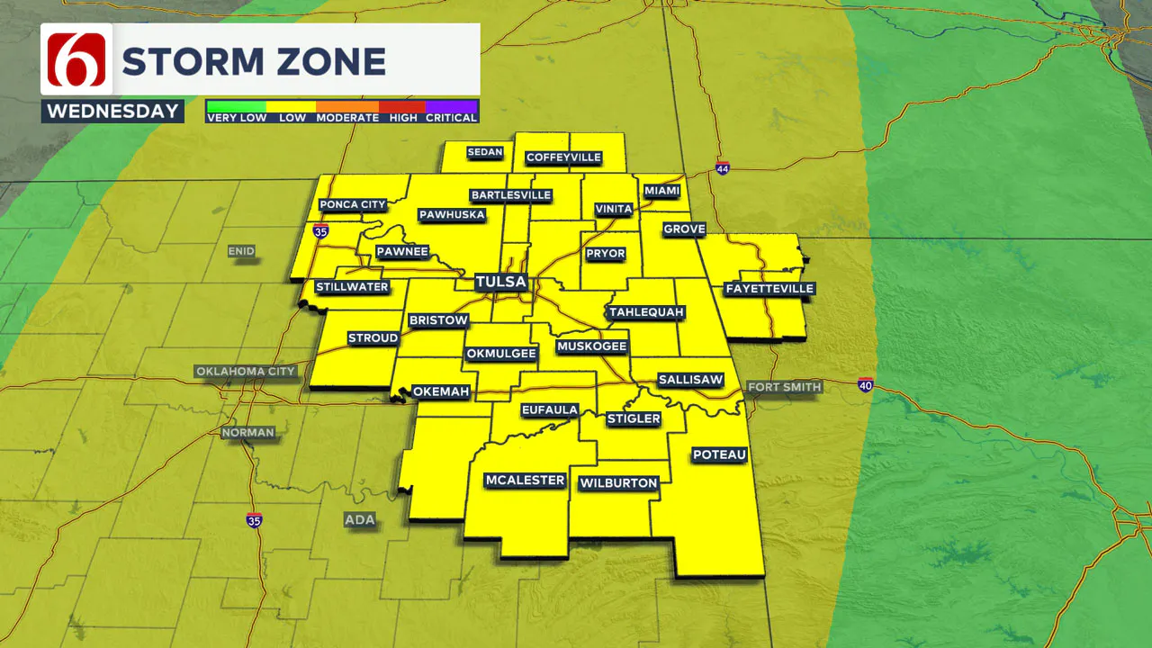
Meteorologist Stacia Knight said most of Green Country will be in the storm zone, with increased chances to the north in Osage and Washington counties.

Isolated storms are possible throughout the afternoon with the main line crossing across Oklahoma at night.
ALL MODES of severe weather, including strong winds, hail and isolated tornado threats, will be possible.
Wednesday's forecast:
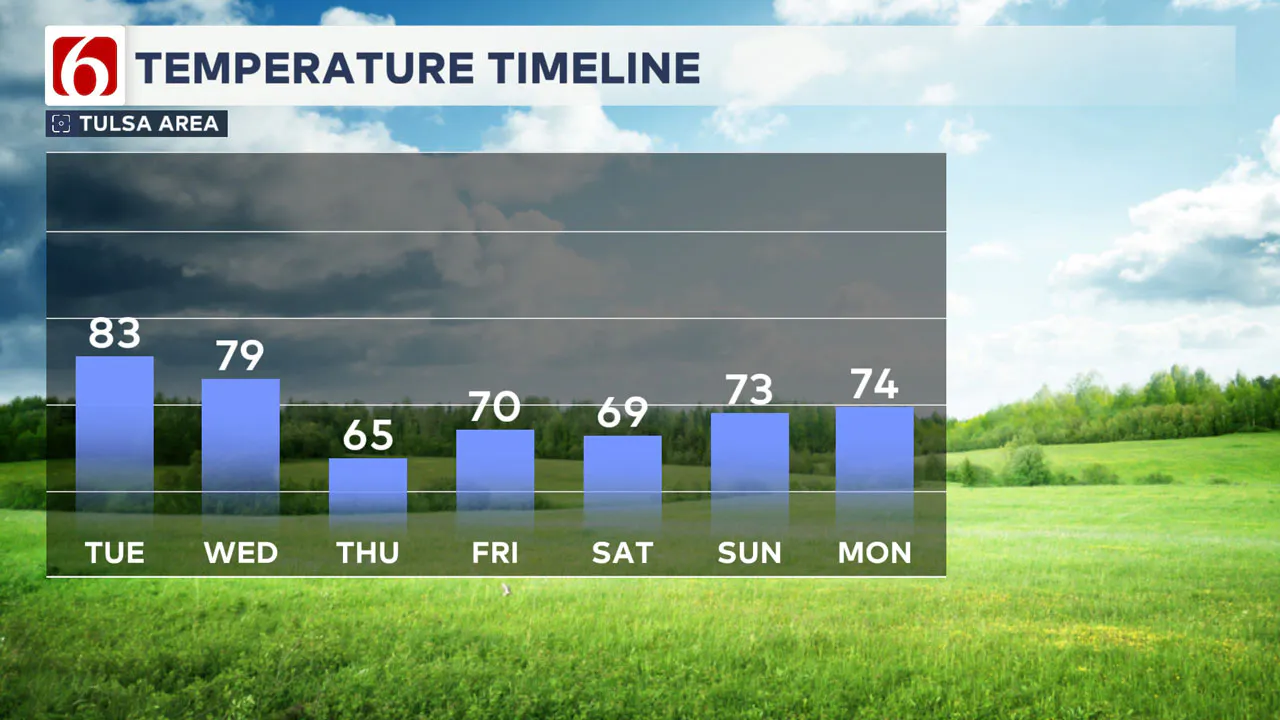
Tomorrow begins with lows around 70, climbing to the upper 70s by the afternoon. The day is expected to be active, with a low-level jet stream and increased moisture possibly bringing isolated showers early in the morning.
As the day progresses, scattered thunderstorms are likely, especially in the afternoon near and east of the dry line in west-central Oklahoma. Strong upper-level winds and lift moving around the Intermountain region will aid storm development across northern Oklahoma and southern Kansas.

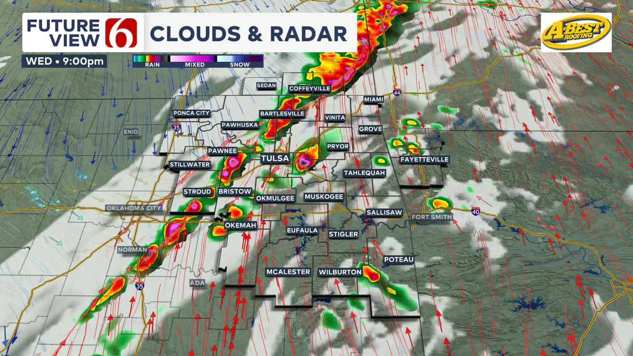
Storms are projected to peak between 3 p.m. and 7 p.m., starting near I-35 and moving northeast, with supercell thunderstorms as the initial concern.

By evening, a cold front interacting with the dry line will trigger additional storms, organizing into a linear pattern with the potential for damaging winds and hail. Although the stronger lift should move out around midnight, severe storms may persist until about 3 a.m. as they exit southeastern Oklahoma.
Halloween forecast:
A cold front moving through late Wednesday will set up the cooler day on Thursday.
Thursday morning will bring temperatures in the 40s and 50s, warming up to the mid-60s by the afternoon with plenty of sunshine and north winds at 10 to 15 mph.

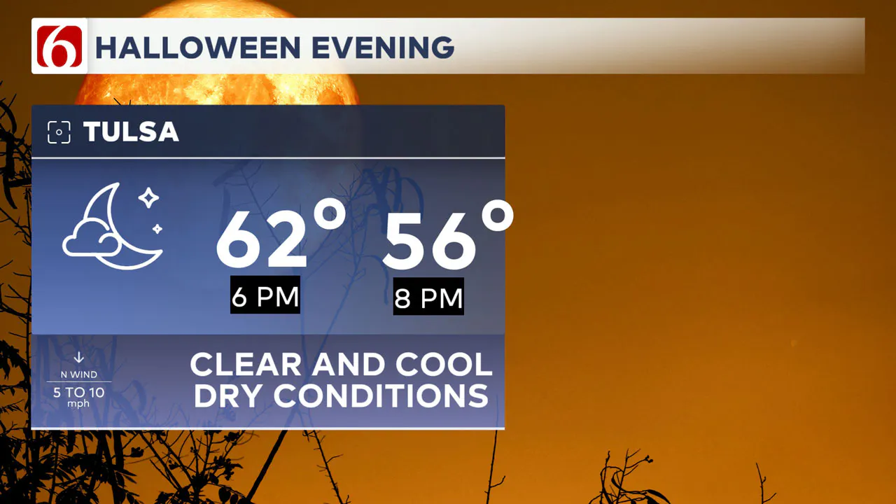
The Halloween forecast looks clear and calm, with lighter winds and cool evening temperatures.
Expect pleasant conditions on Halloween evening, with temperatures in the 50s from 6:30 p.m. to 8:30 p.m.
Friday's forecast:
Friday morning may see some areas dipping into the upper 30s, while the metro area will start in the lower to mid-40s.
Friday afternoon looks seasonal with temperatures approaching 70 degrees and the return of south winds at a 7 to 12 mph clip.

Weekend forecast:
This weekend, a weather system moving in from the west will bring additional chances for showers and storms, especially from Saturday afternoon through Sunday.
Intermittent showers and thunderstorms are likely on Saturday, with south winds at 10 to 20 mph and mostly to partly cloudy skies.
Temperatures will reach the lower 70s, with storm chances increasing into early Sunday morning. Overnight lows will drop into the 50s, while Sunday afternoon highs will again reach the lower 70s.
Next week's forecast:
Following this, another system will likely cause additional showers and storms from Monday into the early afternoon. Some of these systems could impact Election Day.
We’ll continue to monitor the pattern and offer additional information about it tomorrow.
What are the major traffic projects around Tulsa this week?
The Oklahoma Department of Transportation (ODOT) and Oklahoma Turnpike Authority (OTA) provide daily details on several traffic advisories for the Tulsa area and surrounding regions.
To start October, here are some of the significant traffic advisories. For more information, see our detailed list.
I-244 Pavement Rehabilitation
- Ongoing pavement work between I-44 and the Arkansas River bridge, with lane and ramp closures lasting through spring 2025.
US-75 Bridge Rehabilitation
- Lane closures at 7th St. and off-ramp closures to 7th St. through fall 2024 for bridge rehabilitation.
US-412 Bridge Rehabilitation
- US-412 narrowed to two lanes at 81st W. Ave. in Sand Springs through February 2025.
Emergency Info: Outages Across Oklahoma:
Northeast Oklahoma has various power companies and electric cooperatives, many of which have overlapping areas of coverage. Below is a link to various outage maps.
Indian Electric Cooperative (IEC) Outage Map
Oklahoma Association of Electric Cooperatives Outage Map — (Note Several Smaller Co-ops Included)
The Alan Crone morning weather podcast link from Spotify:
https://open.spotify.com/episode/63haLqUelLMhZLdk1GzToQ
The Alan Crone morning weather podcast link from Apple:
Follow the News On 6 Meteorologists on Facebook!

More Like This
October 29th, 2024
October 29th, 2024
October 29th, 2024
Top Headlines
October 29th, 2024
October 29th, 2024


