Beautiful Friday Kicks Off The Weekend, Storms Arrive Sunday Night

Oklahoma Weather Forecast: Bookmark this page and refresh it often for the latest forecast and daily updates.

Friday, November 15th 2024, 6:23 pm

By: News 9


-

It’s a stunning Friday morning across Oklahoma!

It's a mild Friday with conditions that will last through the weekend. Temperatures in the mid-upper 60s and even 70s will return!

We are tracking a storm system that could move in Sunday night and into Monday.

What is the weather like on Friday?

A chilly morning but another mild afternoon will follow as we end the work week.

Highs are expected to reach the upper 60s, which is well above our average high of low 60s for this time of year.

Image

It’s a perfect day for outdoor plans, whether you're headed out to watch high school football playoffs tonight or just enjoying the sunshine.May be an image of map and text

Tonight’s temperatures will drop into the low 50s.

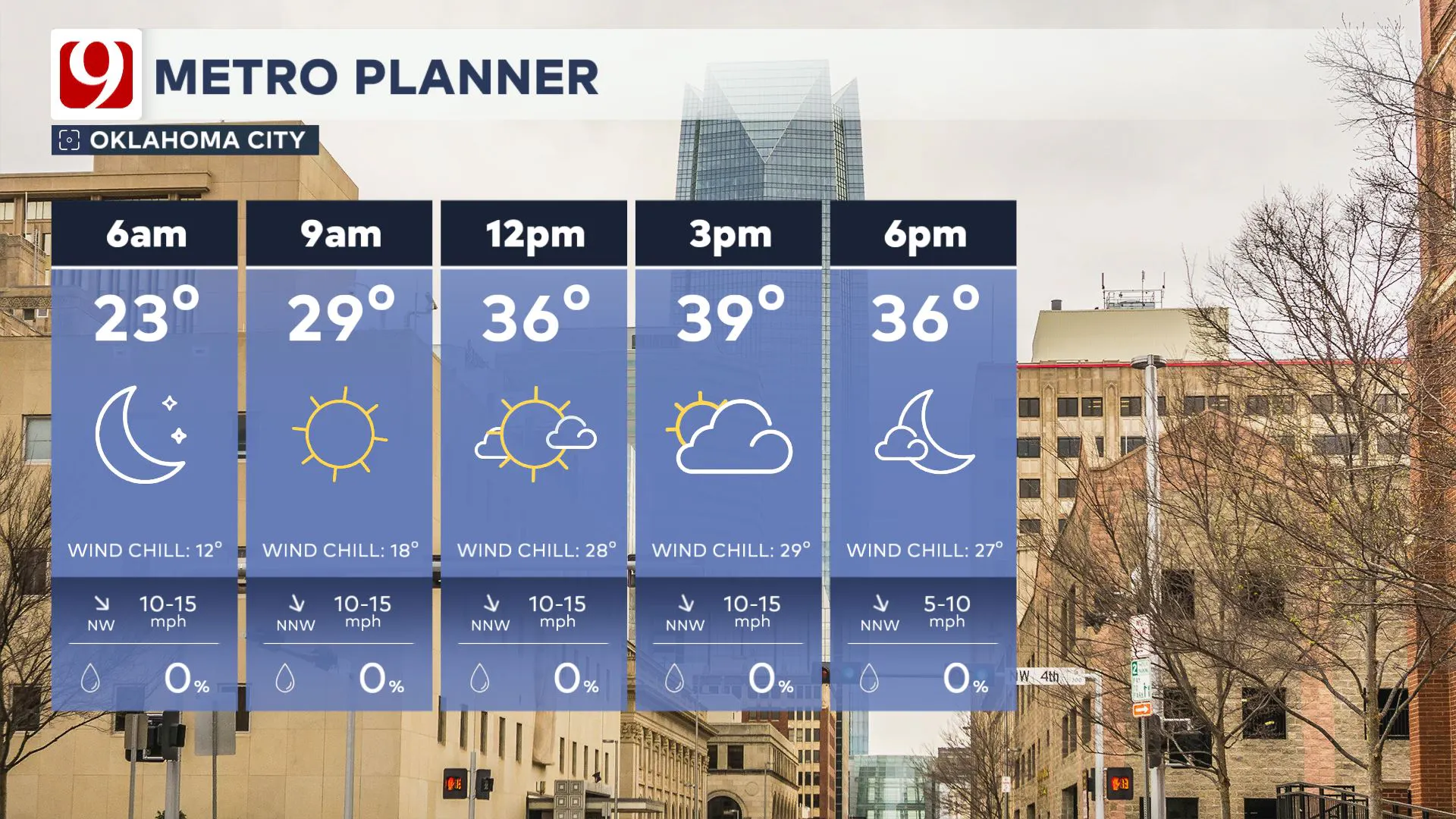
May be an image of map and text that says '9 METRO PLANNER OKLAHOMA CITY 10am 12pm 54 2pm 68° 62° 4pm 66° 6pm 60° CLEAR SKY CLEAR SKY 5 10-15 mph CLEAR SKY S 10-15 mph CLEAR SKY SSE % 10-15 mph CLEAR SKY % SSE 10-15 mph SSE % 10-15 mph % %'

Expect a light breeze that picks up later in the day with gusts around 20-25 mph.

May be an image of windmill and text that says '9 WIND GUST TIMELINE C OKLAHOMA CITY FRIDAY SATU SATURDAY 21 16 23 19 21 19 21 21 21 9am 12pm ٧ 3pm ٧ 6pm ٧ 9pm 12am 3am 6am'

What is the weather like in Oklahoma this weekend?

There will be some wind this weekend, but temperatures will be above average!

Saturday looks fantastic, with highs in the upper 60s and a few locations possibly reaching the low 70s. Expect breezy conditions, with winds gusting 20 to 30 mph. It will be a great day to get outside but be prepared for those winds to pick up, especially in the afternoon. The air will still be dry, and the atmosphere will remain calm for most of the day. If you plan to spend time outdoors, it's another ideal day to enjoy before the weather turns.

Image

 South winds will increase, as will the clouds, especially on Sunday. 

May be an image of map and text that says '9 HIGHS SUNDAY NORMAL:60° 60° 52 GUYMON 60 ALVA HEADLINES 60 WOODWARD 67 PONCACITY 67 PONCA CITY ENID RAIN ARRIVES 70 MIAMI 44 STILLWATER MILD AND BREEZY 40 69 TULSA SA NE 8-16 MPH 65 CLINTON 67 HOBART 67+,70 70 ALTUS LAWTON OKLAHOMA CITY S 10-18 MPH 74 SALLISAW 40 73 MCALESTER 72 ADA 73 ARDMORE 73 DURANT 72 IDABEL'

We are tracking the chances for storms starting Sunday night and lasting into mid-morning on Monday.

Timeline of the Storms:

  1. Sunday Afternoon: As moisture surges into Oklahoma, expect thunderstorms to begin developing in the southwest part of the state by midday Sunday. A few scattered storms could produce strong winds and hail.

May be an image of ‎map and ‎text that says '‎9 CHANCE OF RAIN & STORMS SUNDAY AFTERNOON 20% GUYMON 20% ALVA LEGEND 20% WOODWARD LIKELY 20% ENID 20% MIAMI 20% PONCA CITY 20% STILLWATER 44 MODERATE 20% TULSA 60% CLINTON SLIGHT 30% OKLAHOMA CITY 60% HOBART 40% LAWTON 40 60% ALTUS AL 20% SALLISAW سح 20% ADA 20% MCALESTER 20% ARDMORE 20% DURANT 40% % IDABEL‎'‎‎

  1. Sunday Night (Midnight - 3 AM): The main storm system will begin to affect the state. Thunderstorms will intensify, and severe weather risk increases with the potential for hail, strong winds, and even tornadoes. The timing of this is critical, as the system will be moving through overnight, meaning the heaviest and most severe storms could hit during the early morning hours of Monday.

May be an image of map and text that says '9 CHANCE OF RAIN & STORMS SUNDAY EVENING-SUNDAY -SUNDAY NIGHT-MONDAY MORNING 100% GUYMON LEGEND 100% WOODWARD 100% ALVA 100% ENID LIKELY 100% PONCA CITY 100% % MIAMI 44 MODERATE 100% STILLWATER 100% TULSA 100% CLINTON SLIGHT 100% OKLAHOMA CITY 100% 100% SALLISAW 40 100% AL ALTUS TUS 100% LAWTON 100% MCALESTER 100% ADA 100% ARDMORE 100% 0% DURANT 60% IDABEL'

  1. Monday Morning (2 AM - 7 AM): The line of storms will push east, with the potential for severe weather, including tornadoes, hail up to the size of quarters, and winds around 70 mph. There’s also a concern for flooding, as some areas could see 2-3 inches of rain by the time the system moves out. Be prepared for possible power outages and hazardous driving conditions.

May be an image of map, tornado and text that says '9 STORM ZONE SUNDAY NIGHT MONDAY AFTERNOON UENVER CHICAGO INFO DRAW CLEAR THREAT THREATLEVEL LEVEL HIGH INDIANAPOLIS SAINT SAINTLOUIS LOUIS MODERATEBUQUERQUI ER QUE MODERATE LOUISVILLE PHC LOW NASHVILLE L LITTLEROCK THREATS DAMAGING WIND FLOODING ISOLATED TORNADOES ELPASO MIDLAND ND LAS ATLANTA JACKSON SON JACK CHIHUAHUA HOUSTON NEW NEWORLEANS ORLE ORLEANS ANS'

  1. Monday Afternoon: By Monday afternoon, the storm system will have moved east, and the weather will quiet down, leaving behind a cool and calm afternoon with temperatures in the 50s and 60s.

May be an image of map and text

This setup is still several days away, so stay tuned as the timing and the zones become more refined. We could see more rain into next week.

May be an image of body of water and text

COLD FRONT:

It's turning cold next week! We will see two cold blasts and may see some snow chances in parts of the state.

We are watching the first big cold blast around November 20!

This will bring the coldest air of the season to Oklahoma, likely widespread in the 20s. Some data suggests a little snow, but we will see.

May be an image of map and text

Follow our meteorologists!

Meteorologist David Payne

Meteorologist Lacey Swope

Meteorologist Jed Castles

Meteorologist Cassie Heiter

Meteorologist Justin Rudicel

Meteorologist Andrew Adams

logo

Get The Daily Update!

Be among the first to get breaking news, weather, and general news updates from News on 6 delivered right to your inbox!

More Like This

November 15th, 2024

November 15th, 2024

November 15th, 2024

November 15th, 2024

Top Headlines

November 15th, 2024

November 15th, 2024

November 15th, 2024

November 15th, 2024