

Maps Show Tropical Storm Debby's Path And Forecast
Tropical Storm Debby was barreling across northern Florida on Monday morning after making landfall over the state's Big Bend coast as a Category 1 hurricane. Even with the slight dip in intensity, Debby was forecast to bring dangerous storm surge to parts of the Gulf Coast of Florida through Monday afternoon.Monday, August 5th 2024, 3:12 pm

Tropical Storm Debby was barreling across northern Florida on Monday morning after making landfall over the state's Big Bend coast as a Category 1 hurricane. Even with the slight dip in intensity, Debby was forecast to bring dangerous storm surge to parts of the Gulf Coast of Florida through Monday afternoon.
The storm could bring historic rainfall to surrounding states like Georgia and South Carolina, too, the National Hurricane Center said, warning that Debby was expected to cause "major flooding" to parts of the southeastern United States over the next several days.
Debby slammed into the Big Bend coast, where the Florida panhandle meets the peninsula, near Steinhatchee, a small oceanside town about 70 miles west of Gainesville, at around 7 a.m. EDT. The hurricane center said it was was tracking slightly inland in the Big Bend region about an hour after landfall, with maximum sustained winds of 75 miles per hour. That marked a marginal decrease in power, as meteorologists estimated that Debby struck the coast with 80 mph winds.
By 2 p.m., sustained wind speeds had fallen to about 65 mph, with higher gusts, as the tropical storm churned along its anticipated north-northeastern route. Meteorologists said at the time that Debby was located about 10 miles northwest of Live Oak, Florida, and traveling at around 7 mph. Tropical-storm-force winds extended outward up to 140 miles from the eye of the storm, which was expected to gradually weaken over the coming days.

Meteorologists expected that storm surge would be most catastrophic in the immediate vicinity of the landfall location, with initial forecasts indicating a 130-mile stretch of coastline between Yankeetown and the Aucilla River could see surges between 6 and 10 feet above ground. Storm surge threats gradually lessened as the hours passed after Debby's landfall, with forecasters saying by the afternoon that peak surge in that region would look more like 3 to 5 feet.
The National Hurricane Center published maps on Monday illustrating the storm surge forecast.
The below map, updated on Monday afternoon, shows the highest potential values in the peak surge range, and includes the tide, the hurricane center said. Meteorologists noted that the timing of peak surge and high tide in a given area, and whether they coincide or not, will ultimately determine how destructive the inundation will be.
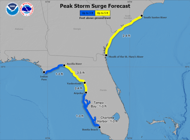
Storm surge threats were expected to abate farther into the panhandle and down the length of the Gulf Coast — but only somewhat. Meteorologists warned that surges as high as 3 feet could hit areas west of the Aucilla River to Indian Pass, and south of Yankeetown to Bonita Beach. That stretch includes Tampa Bay and the surrounding area. A shorter stretch of the Gulf Coast from Yankeetown to Aripeka was still at risk of slightly higher surges at 2 p.m., according to the hurricane center.
Coastal places as far south as Bonita Beach could see heavy rainfall coupled with storm surge for the next several days as a result of the tropical storm. So could coastal areas along a vast stretch of the southeastern U.S., from the mouth of the St. Mary's River, around where Florida meets Georgia, up to the South Santee River in South Carolina. That southeastern stretch includes major cities in both states, Savannah and Charleston, and could weather storm surge up to 4 feet above ground as Debby continues to turn northeastward.
Debby was slowing down after making landfall on Monday, and the hurricane center said that the anticipated rainfall totals along its path are so massive in part because the storm is lingering over each place it passes.
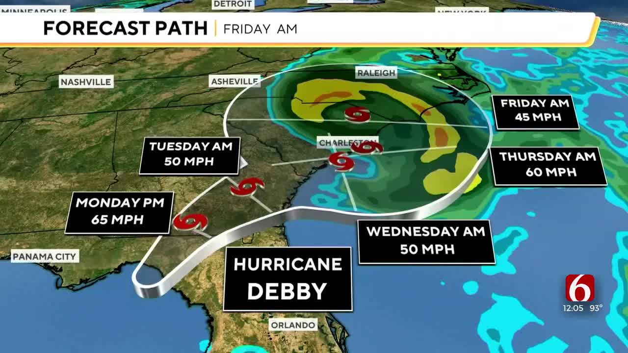
As it shifts farther east, the storm was expected to touch an expansive spread along the southeastern U.S. through the Carolinas before dissipating. In the hurricane center's most recent path forecast for Debby, meteorologists projected the storm would continue tracking across northern Florida and up through a portion of the southeastern coast of Georgia later on Monday and into Tuesday. The latest forecasts extended by 6 hours the time frame in which Debby would travel up to Georgia and the Carolinas.

Forecasts suggested the storm could move off a linear path again late Tuesday and Wednesday, traveling inland while continuing northward to South Carolina and then likely turning back toward the coast on Thursday.
The hurricane center had predicted that Debby would weaken rapidly after the eye of the storm moved inland into northern Florida, shifting back into a tropical storm. But meteorologists also warned that Debby could strengthen again after an initial period of weakening, depending on whether it oscillates between an inland and coastal path during its route over the southeastern states.
Debby was also expected to dump heavy rain totaling 6 to 12 inches, and even as high as 18 inches in some places, across central and northern Florida as well as central and northeast North Carolina throughout the rest of the week until Saturday morning. Meteorologists warned that the rainfall would likely cause considerable flash and urban flooding, and significant river flooding, in parts of the affected states.
Portions of southeast Georgia, the coastal plains of South Carolina and southeast North Carolina could see 10 to 20 inches of rainfall as Debby continues on its path, with maximum rainfall amounts as high as 30 inches, or almost three feet, in certain areas.
None of the formidable rainfall estimates or related flood warnings have changed since Debby made landfall, even after it was downgraded to a tropical storm.

A handful of tornadoes could develop over central and northern Florida, as well as southeastern Georgia, on Monday, forecasters said. The tornado threat was expected to travel northeastward with the storm, into parts of South Carolina, later in the day and into Monday night.

Get The Daily Update!
Be among the first to get breaking news, weather, and general news updates from News on 6 delivered right to your inbox!
More Like This

August 5th, 2024


May 12th, 2025
Top Headlines

June 3rd, 2025


