

Easter Weekend Weather Timeline: Expect waves of rain and storms
Oklahoma’s Easter weekend forecast includes severe storms on Friday, widespread rain on Saturday, and a soggy start to Sunday before conditions improve by afternoon.Thursday, April 17th 2025, 11:24 am

Friday: Storms Move In
Friday morning brings a 30–40% chance of scattered showers as Gulf moisture surges northward. Showers may pop up in and around the metro and east of I-35 through midday.
By late afternoon and evening, storm chances increase significantly, especially after 5 p.m., and metro storm chances ramp up even more after 7 p.m. Numerous storms are expected to fire along and ahead of a strong cold front sweeping across the state.
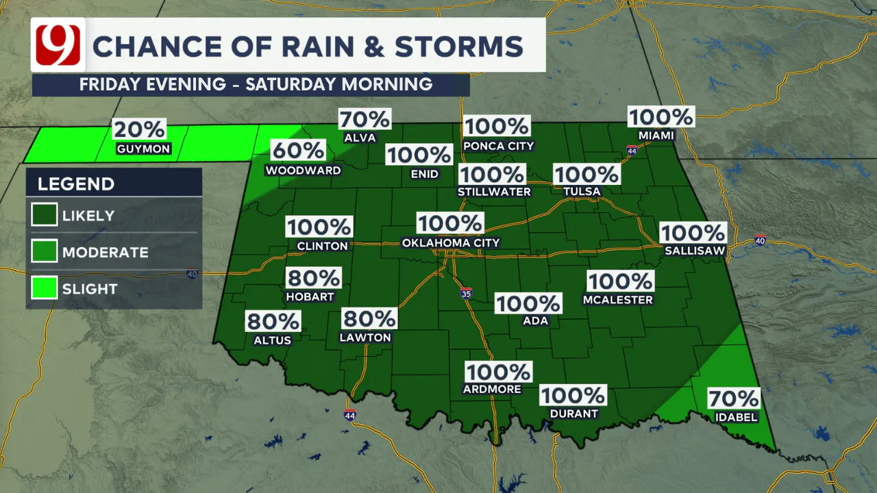
The timing and placement of this front are key. South of the front, where temperatures remain warm and unstable, strong to severe storms are possible, including quarter to golf ball-sized hail and a low tornado risk. North of the front, storms will be elevated—capable of producing damaging winds and hail, but without a tornado threat.
Temperatures in Oklahoma City will likely spike into the 70s or 80s ahead of the front, then fall into the 50s and 60s by Friday evening as cooler air moves in.
Saturday: Waves of Rain, Isolated Severe Storms
Expect a soggy start to Saturday with widespread rain and lingering storms from Friday night. Off-and-on rain continues throughout the day in waves. While there will be some dry periods, a few strong to severe storms may redevelop in southeast Oklahoma, depending on where the front stalls.
A second round of statewide rain arrives Saturday night into early Sunday morning, continuing into Easter morning.

Easter Sunday: Wet Start, Dry Finish
The forecast still calls for rain through at least midday on Sunday, with the chance it may linger into the early afternoon before tapering off. By Sunday evening, skies should begin to clear.
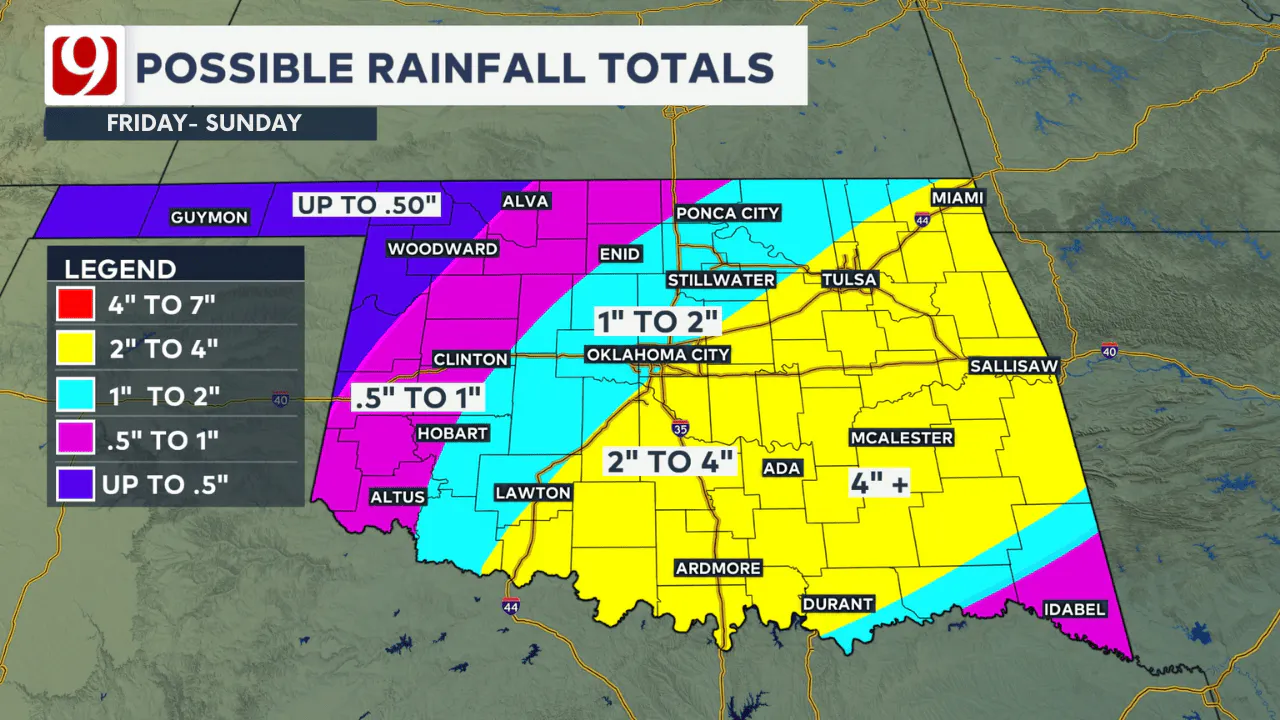
Rainfall totals through the weekend could reach 1–2 inches across central Oklahoma, with localized pockets of 2–4 inches possible. Western Oklahoma may see around half an inch to an inch.
Looking Ahead
After a wet weekend, we get a short break Monday with sunshine and highs in the 70s. However, storm chances return almost daily next week. Our team will continue to monitor those threats and provide updates as they develop.
Be Weather-Aware This Weekend
With severe storm potential beginning Friday, now’s the time to stay weather-aware. The News 9 weather team and trackers will be out in full force bringing you live updates throughout the weekend.
Make sure your weather apps are updated and your safety plans are in place—especially if you have outdoor Easter plans!


Justin Rudicel
Meteorologist Justin Rudicel has been part of the News 9 team since 2014. You can watch his forecasts weekdays on News 9 at Noon. At the young age of five years old, Justin became hooked on weather as this Hoosier experienced all kinds of big weather events growing up in Indianapolis, Indiana. He also loves sports and photography.

Anna Denison
Anna is the Lead Digital Producer at News 9 and has been creating and managing social media content and online articles for the newsroom since October of 2024.

Get The Daily Update!
Be among the first to get breaking news, weather, and general news updates from News on 6 delivered right to your inbox!
More Like This

April 17th, 2025


June 9th, 2025
June 9th, 2025


