Rain Returns To Northeast Oklahoma Through The Weekend
<p>Grab the rain gear and keep it handy for the next few days. You’ll eventually need the coat! </p>Friday, October 12th 2018, 3:53 am
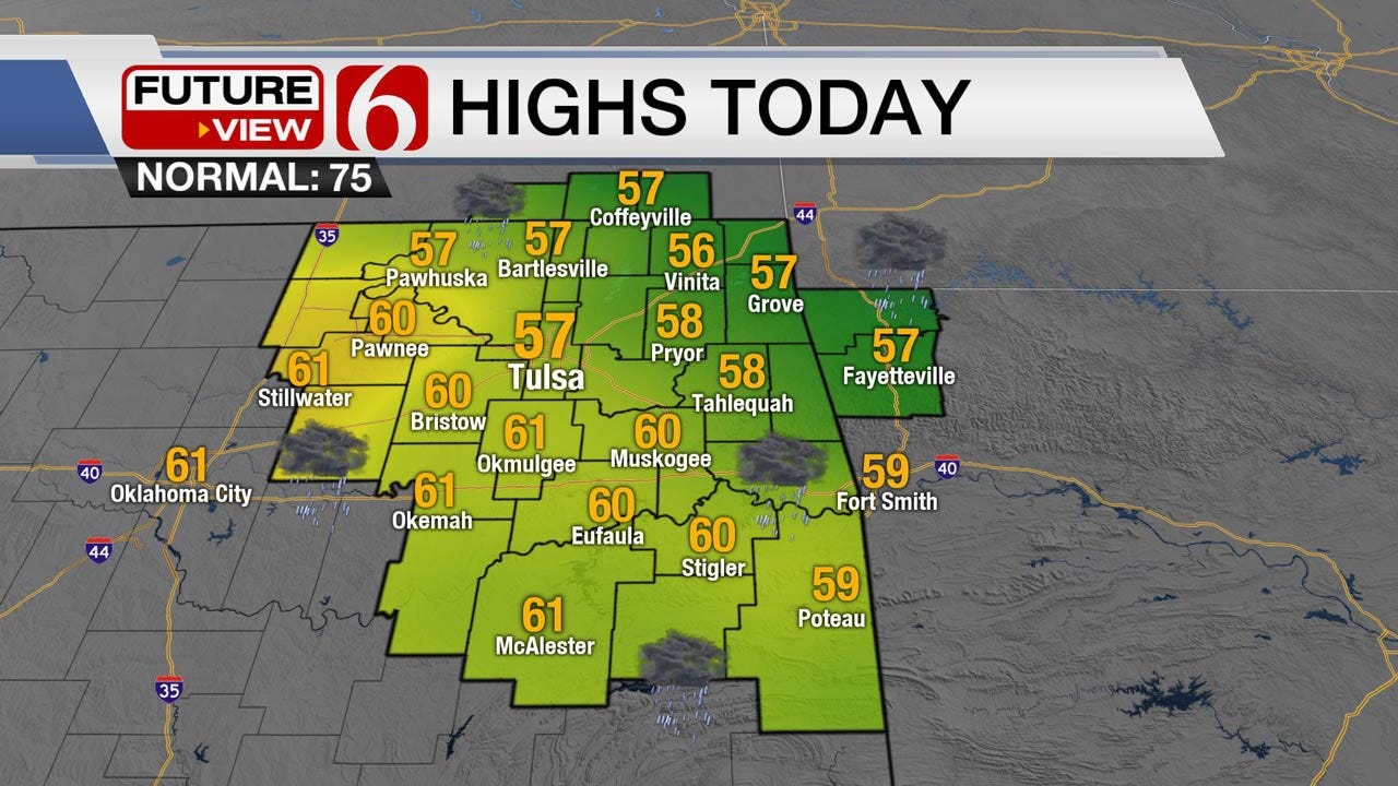
Grab the rain gear and keep it handy for the next few days. You’ll eventually need the coat! A short wave is moving across the northern plains into Kansas this morning and is helping to producing light showers across a large area of Kansas into central and eastern Oklahoma. Amounts will be very light, but this should result in a decent coverage for the next few hours. I’ll expect most of this precip to be east of the region around the noon to 2 p.m. period. We may even see the clouds clearing from the west to east briefly before most of the Friday Night Football games get underway. The exception: far southeastern Oklahoma may still deal with a few showers for the first quarter. Temps today will stay in the mid to upper 50s north and a few lower 60s south. Heavier rainfall is still in the forecast for part of Saturday as moisture from the old Sergio tropical system merges with a developing storm system across the state. Severe weather threats should remain well south of our area.
The timing for the rainfall Saturday continues to be slightly problematic. While the chances are high in most of the data, the start and stop times differ. Some of the hi-res data support a start time around 11 a.m. to 1 p.m. tomorrow morning near the metro. I’ll skip all the individual models and their output and keep our forecast a compromise of the blend. We’ll have increasing rain chances by 1 to 3 p.m. Saturday with a likely category Saturday evening. Sunday morning the heaviest rainfall should be east of the region, but additional showers are still possible due to another system quickly moving down the plains.
Sunday midday to afternoon a surface front will quickly move across the state with temps falling from the mid-50s into the upper 40s by the afternoon along with gusty north winds and generally blustery weather. Moisture is still expected to overrun the backside of the boundary Sunday evening into early Monday with some additional rain possible near and east/south of the metro. The air will be cold and deep enough to support some snow in the Oklahoma panhandles, possibly into far northwestern Oklahoma. This will remain well west of our area, but we’ll deal with some rainfall Monday morning near and southeast for the morning hours.
Monday we’ll start with low temps near 40. We’ll probably stay in the mid to upper 40s for the daytime highs before clouds begin to clear from the northwest to south by early Tuesday morning. If this process does occur on schedule, temps will drop into the mid to upper 30s Tuesday morning with the first frost of the season across most of northern Oklahoma. A few spots could hit freezing. Tuesday afternoon the temps will move into the upper 50s to lower 60s with warming conditions expected Wednesday through the end of next week before another weak wave nears the state by next Friday.
Thanks for reading the Friday morning weather discussion and blog.
More Like This
October 12th, 2018
September 29th, 2024
September 17th, 2024
Top Headlines
November 26th, 2024
November 25th, 2024
November 25th, 2024
November 25th, 2024


